You are here: Home > Network List > TA - USArray Transportable Network (new EarthScope stations) Stations List
> Station 243A Waterproof, LA, USA > Earthquake Result Viewer
243A Waterproof, LA, USA - Earthquake Result Viewer
| Earthquake location: |
Queen Charlotte Islands Region |
| Earthquake latitude/longitude: |
52.8/-132.1 |
| Earthquake time(UTC): |
2012/10/28 (302) 03:04:08 GMT |
| Earthquake Depth: |
14 km |
| Earthquake Magnitude: |
6.5 MB, 7.5 MS, 7.8 MW, 7.8 MW |
| Earthquake Catalog/Contributor: |
WHDF/NEIC |
|
| Network: |
TA USArray Transportable Network (new EarthScope stations) |
| Station: |
243A Waterproof, LA, USA |
| Lat/Lon: |
31.88 N/91.48 W |
| Elevation: |
2.0 m |
|
| Distance: |
35.9 deg |
| Az: |
109.287 deg |
| Baz: |
317.636 deg |
| Ray Param: |
0.076948345 |
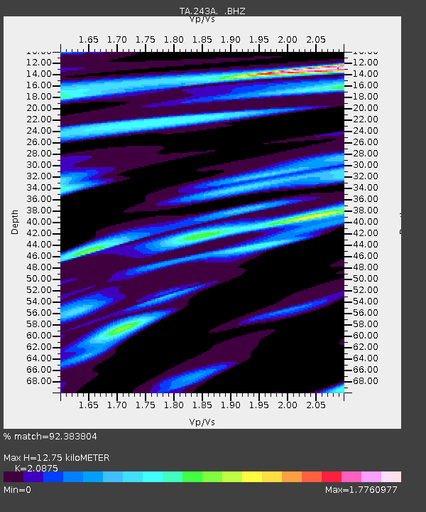
| Estimated Moho Depth: |
12.75 km |
| Estimated Crust Vp/Vs: |
2.09 |
| Assumed Crust Vp: |
6.065 km/s |
| Estimated Crust Vs: |
2.905 km/s |
| Estimated Crust Poisson's Ratio: |
0.35 |
|
| Radial Match: |
92.383804 % |
| Radial Bump: |
384 |
| Transverse Match: |
79.411316 % |
| Transverse Bump: |
400 |
| SOD ConfigId: |
478790 |
| Insert Time: |
2013-03-01 08:34:39.203 +0000 |
| GWidth: |
2.5 |
| Max Bumps: |
400 |
| Tol: |
0.001 |
|
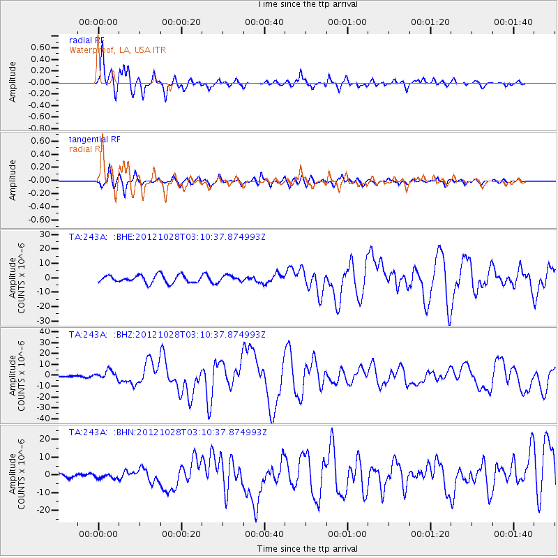
Signal To Noise
| Channel | StoN | STA | LTA |
| TA:243A: :BHZ:20121028T03:10:37.874993Z | 5.6581063 | 3.9520164E-6 | 6.9846976E-7 |
| TA:243A: :BHN:20121028T03:10:37.874993Z | 0.4508716 | 1.19714E-6 | 2.6551686E-6 |
| TA:243A: :BHE:20121028T03:10:37.874993Z | 0.7595045 | 2.0067887E-6 | 2.642234E-6 |
| Arrivals |
| Ps | 2.4 SECOND |
| PpPs | 6.1 SECOND |
| PsPs/PpSs | 8.6 SECOND |


