You are here: Home > Network List > TA - USArray Transportable Network (new EarthScope stations) Stations List
> Station 245A Little AP, Star, MS, USA > Earthquake Result Viewer
245A Little AP, Star, MS, USA - Earthquake Result Viewer

| Earthquake location: |
Queen Charlotte Islands Region |
| Earthquake latitude/longitude: |
52.8/-132.1 |
| Earthquake time(UTC): |
2012/10/28 (302) 03:04:08 GMT |
| Earthquake Depth: |
14 km |
| Earthquake Magnitude: |
6.5 MB, 7.5 MS, 7.8 MW, 7.8 MW |
| Earthquake Catalog/Contributor: |
WHDF/NEIC |
|
| Network: |
TA USArray Transportable Network (new EarthScope stations) |
| Station: |
245A Little AP, Star, MS, USA |
| Lat/Lon: |
32.03 N/89.90 W |
| Elevation: |
104 m |
|
| Distance: |
36.7 deg |
| Az: |
107.44 deg |
| Baz: |
316.984 deg |
| Ray Param: |
0.07651077 |
| Estimated Moho Depth: |
15.0 km |
| Estimated Crust Vp/Vs: |
2.10 |
| Assumed Crust Vp: |
6.201 km/s |
| Estimated Crust Vs: |
2.957 km/s |
| Estimated Crust Poisson's Ratio: |
0.35 |
|
| Radial Match: |
86.699295 % |
| Radial Bump: |
315 |
| Transverse Match: |
61.856216 % |
| Transverse Bump: |
400 |
| SOD ConfigId: |
478790 |
| Insert Time: |
2013-03-01 08:36:15.571 +0000 |
| GWidth: |
2.5 |
| Max Bumps: |
400 |
| Tol: |
0.001 |
|
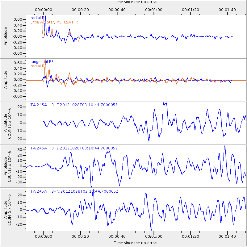
Signal To Noise
| Channel | StoN | STA | LTA |
| TA:245A: :BHZ:20121028T03:10:44.700005Z | 3.9023585 | 3.3365502E-6 | 8.5500864E-7 |
| TA:245A: :BHN:20121028T03:10:44.700005Z | 1.0467463 | 2.8225734E-6 | 2.6965213E-6 |
| TA:245A: :BHE:20121028T03:10:44.700005Z | 1.3440499 | 3.1021257E-6 | 2.3080436E-6 |
| Arrivals |
| Ps | 2.8 SECOND |
| PpPs | 7.1 SECOND |
| PsPs/PpSs | 9.9 SECOND |


