You are here: Home > Network List > TA - USArray Transportable Network (new EarthScope stations) Stations List
> Station Y43A Makayla and Karen, Gunnison, MS, USA > Earthquake Result Viewer
Y43A Makayla and Karen, Gunnison, MS, USA - Earthquake Result Viewer
| Earthquake location: |
Queen Charlotte Islands Region |
| Earthquake latitude/longitude: |
52.8/-132.1 |
| Earthquake time(UTC): |
2012/10/28 (302) 03:04:08 GMT |
| Earthquake Depth: |
14 km |
| Earthquake Magnitude: |
6.5 MB, 7.5 MS, 7.8 MW, 7.8 MW |
| Earthquake Catalog/Contributor: |
WHDF/NEIC |
|
| Network: |
TA USArray Transportable Network (new EarthScope stations) |
| Station: |
Y43A Makayla and Karen, Gunnison, MS, USA |
| Lat/Lon: |
33.91 N/90.93 W |
| Elevation: |
46 m |
|
| Distance: |
34.8 deg |
| Az: |
106.294 deg |
| Baz: |
315.495 deg |
| Ray Param: |
0.07755677 |
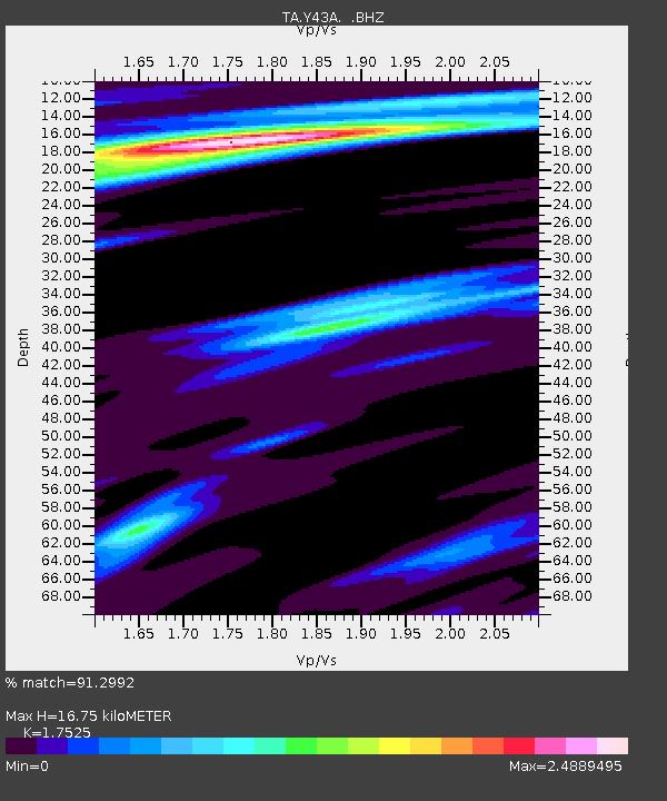
| Estimated Moho Depth: |
16.75 km |
| Estimated Crust Vp/Vs: |
1.75 |
| Assumed Crust Vp: |
6.201 km/s |
| Estimated Crust Vs: |
3.539 km/s |
| Estimated Crust Poisson's Ratio: |
0.26 |
|
| Radial Match: |
91.2992 % |
| Radial Bump: |
268 |
| Transverse Match: |
84.46426 % |
| Transverse Bump: |
319 |
| SOD ConfigId: |
478790 |
| Insert Time: |
2013-03-01 08:37:11.597 +0000 |
| GWidth: |
2.5 |
| Max Bumps: |
400 |
| Tol: |
0.001 |
|

Signal To Noise
| Channel | StoN | STA | LTA |
| TA:Y43A: :BHZ:20121028T03:10:27.974999Z | 4.133594 | 3.9964543E-6 | 9.668231E-7 |
| TA:Y43A: :BHN:20121028T03:10:27.974999Z | 0.72892016 | 1.4973896E-6 | 2.0542575E-6 |
| TA:Y43A: :BHE:20121028T03:10:27.974999Z | 0.67615473 | 2.613796E-6 | 3.865677E-6 |
| Arrivals |
| Ps | 2.2 SECOND |
| PpPs | 6.9 SECOND |
| PsPs/PpSs | 9.1 SECOND |


