You are here: Home > Network List > TA - USArray Transportable Network (new EarthScope stations) Stations List
> Station Y47A UCPARC, Winfield, AL, USA > Earthquake Result Viewer
Y47A UCPARC, Winfield, AL, USA - Earthquake Result Viewer
| Earthquake location: |
Queen Charlotte Islands Region |
| Earthquake latitude/longitude: |
52.8/-132.1 |
| Earthquake time(UTC): |
2012/10/28 (302) 03:04:08 GMT |
| Earthquake Depth: |
14 km |
| Earthquake Magnitude: |
6.5 MB, 7.5 MS, 7.8 MW, 7.8 MW |
| Earthquake Catalog/Contributor: |
WHDF/NEIC |
|
| Network: |
TA USArray Transportable Network (new EarthScope stations) |
| Station: |
Y47A UCPARC, Winfield, AL, USA |
| Lat/Lon: |
33.90 N/87.85 W |
| Elevation: |
160 m |
|
| Distance: |
36.6 deg |
| Az: |
103.196 deg |
| Baz: |
314.688 deg |
| Ray Param: |
0.07658665 |
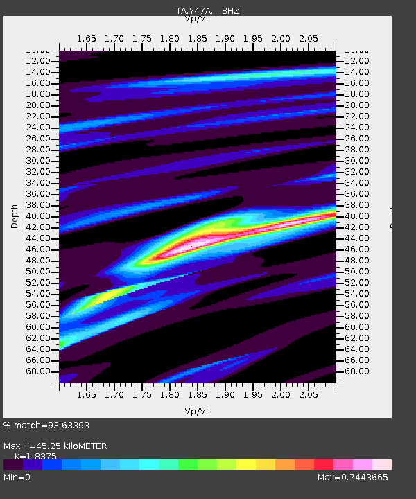
| Estimated Moho Depth: |
45.25 km |
| Estimated Crust Vp/Vs: |
1.84 |
| Assumed Crust Vp: |
6.565 km/s |
| Estimated Crust Vs: |
3.573 km/s |
| Estimated Crust Poisson's Ratio: |
0.29 |
|
| Radial Match: |
93.63393 % |
| Radial Bump: |
233 |
| Transverse Match: |
74.272766 % |
| Transverse Bump: |
400 |
| SOD ConfigId: |
478790 |
| Insert Time: |
2013-03-01 08:37:21.226 +0000 |
| GWidth: |
2.5 |
| Max Bumps: |
400 |
| Tol: |
0.001 |
|

Signal To Noise
| Channel | StoN | STA | LTA |
| TA:Y47A: :BHZ:20121028T03:10:43.524987Z | 2.2167904 | 2.7948574E-6 | 1.2607675E-6 |
| TA:Y47A: :BHN:20121028T03:10:43.524987Z | 1.8239585 | 1.6269238E-6 | 8.919741E-7 |
| TA:Y47A: :BHE:20121028T03:10:43.524987Z | 1.1870421 | 8.300328E-7 | 6.992446E-7 |
| Arrivals |
| Ps | 6.2 SECOND |
| PpPs | 18 SECOND |
| PsPs/PpSs | 24 SECOND |


