You are here: Home > Network List > TA - USArray Transportable Network (new EarthScope stations) Stations List
> Station Z45A Winona, MS, USA > Earthquake Result Viewer
Z45A Winona, MS, USA - Earthquake Result Viewer
| Earthquake location: |
Queen Charlotte Islands Region |
| Earthquake latitude/longitude: |
52.8/-132.1 |
| Earthquake time(UTC): |
2012/10/28 (302) 03:04:08 GMT |
| Earthquake Depth: |
14 km |
| Earthquake Magnitude: |
6.5 MB, 7.5 MS, 7.8 MW, 7.8 MW |
| Earthquake Catalog/Contributor: |
WHDF/NEIC |
|
| Network: |
TA USArray Transportable Network (new EarthScope stations) |
| Station: |
Z45A Winona, MS, USA |
| Lat/Lon: |
33.37 N/89.69 W |
| Elevation: |
113 m |
|
| Distance: |
35.9 deg |
| Az: |
105.673 deg |
| Baz: |
315.67 deg |
| Ray Param: |
0.07697171 |
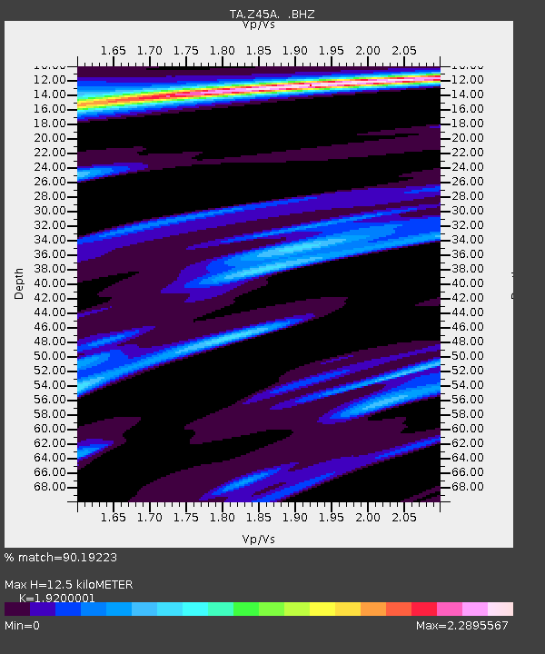
| Estimated Moho Depth: |
12.5 km |
| Estimated Crust Vp/Vs: |
1.92 |
| Assumed Crust Vp: |
6.201 km/s |
| Estimated Crust Vs: |
3.23 km/s |
| Estimated Crust Poisson's Ratio: |
0.31 |
|
| Radial Match: |
90.19223 % |
| Radial Bump: |
363 |
| Transverse Match: |
71.56442 % |
| Transverse Bump: |
400 |
| SOD ConfigId: |
478790 |
| Insert Time: |
2013-03-01 08:38:03.880 +0000 |
| GWidth: |
2.5 |
| Max Bumps: |
400 |
| Tol: |
0.001 |
|

Signal To Noise
| Channel | StoN | STA | LTA |
| TA:Z45A: :BHZ:20121028T03:10:37.499993Z | 4.623275 | 4.2663432E-6 | 9.2279686E-7 |
| TA:Z45A: :BHN:20121028T03:10:37.499993Z | 1.0129819 | 2.2689421E-6 | 2.2398644E-6 |
| TA:Z45A: :BHE:20121028T03:10:37.499993Z | 1.2831196 | 3.6893825E-6 | 2.8753225E-6 |
| Arrivals |
| Ps | 2.0 SECOND |
| PpPs | 5.5 SECOND |
| PsPs/PpSs | 7.5 SECOND |


