You are here: Home > Network List > TA - USArray Transportable Network (new EarthScope stations) Stations List
> Station R42A Luebbering, MO, USA > Earthquake Result Viewer
R42A Luebbering, MO, USA - Earthquake Result Viewer
| Earthquake location: |
Queen Charlotte Islands Region |
| Earthquake latitude/longitude: |
52.8/-132.1 |
| Earthquake time(UTC): |
2012/10/28 (302) 03:04:08 GMT |
| Earthquake Depth: |
14 km |
| Earthquake Magnitude: |
6.5 MB, 7.5 MS, 7.8 MW, 7.8 MW |
| Earthquake Catalog/Contributor: |
WHDF/NEIC |
|
| Network: |
TA USArray Transportable Network (new EarthScope stations) |
| Station: |
R42A Luebbering, MO, USA |
| Lat/Lon: |
38.28 N/90.79 W |
| Elevation: |
218 m |
|
| Distance: |
31.9 deg |
| Az: |
100.36 deg |
| Baz: |
310.612 deg |
| Ray Param: |
0.07888225 |
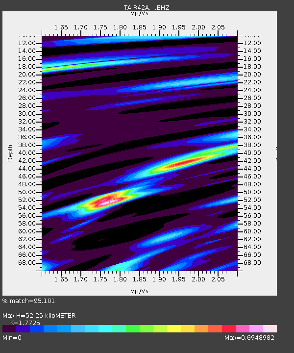
| Estimated Moho Depth: |
52.25 km |
| Estimated Crust Vp/Vs: |
1.77 |
| Assumed Crust Vp: |
6.498 km/s |
| Estimated Crust Vs: |
3.666 km/s |
| Estimated Crust Poisson's Ratio: |
0.27 |
|
| Radial Match: |
95.101 % |
| Radial Bump: |
260 |
| Transverse Match: |
66.31508 % |
| Transverse Bump: |
400 |
| SOD ConfigId: |
478790 |
| Insert Time: |
2013-03-01 08:40:37.918 +0000 |
| GWidth: |
2.5 |
| Max Bumps: |
400 |
| Tol: |
0.001 |
|
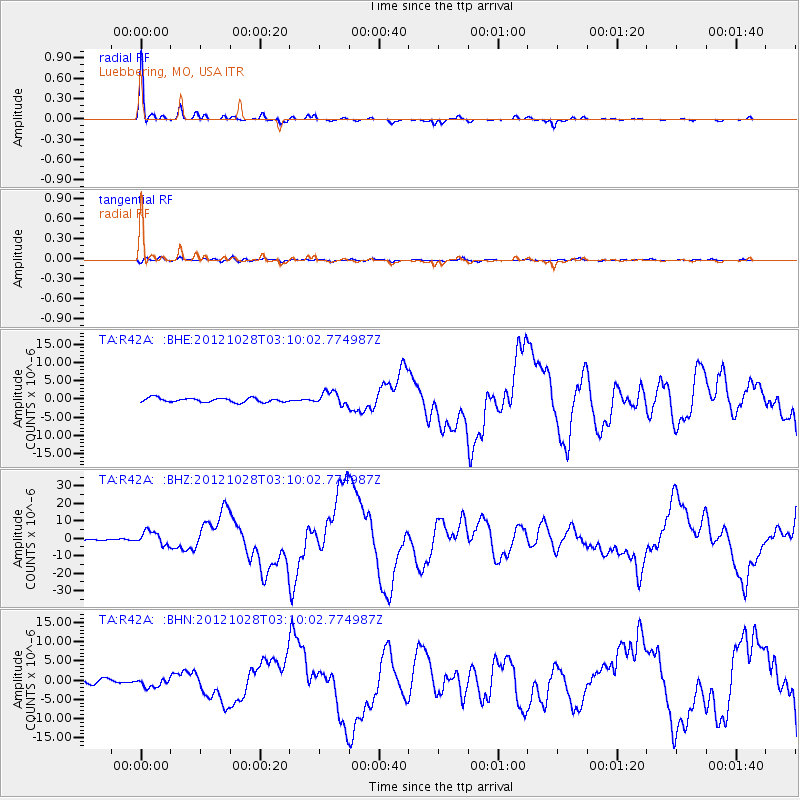
Signal To Noise
| Channel | StoN | STA | LTA |
| TA:R42A: :BHZ:20121028T03:10:02.774987Z | 7.3189735 | 3.8858675E-6 | 5.3093066E-7 |
| TA:R42A: :BHN:20121028T03:10:02.774987Z | 2.1473594 | 1.1186572E-6 | 5.209455E-7 |
| TA:R42A: :BHE:20121028T03:10:02.774987Z | 3.1257467 | 1.8050008E-6 | 5.7746223E-7 |
| Arrivals |
| Ps | 6.7 SECOND |
| PpPs | 21 SECOND |
| PsPs/PpSs | 27 SECOND |


