You are here: Home > Network List > TA - USArray Transportable Network (new EarthScope stations) Stations List
> Station N42A Yates City, IL, USA > Earthquake Result Viewer
N42A Yates City, IL, USA - Earthquake Result Viewer
| Earthquake location: |
Queen Charlotte Islands Region |
| Earthquake latitude/longitude: |
52.8/-132.1 |
| Earthquake time(UTC): |
2012/10/28 (302) 03:04:08 GMT |
| Earthquake Depth: |
14 km |
| Earthquake Magnitude: |
6.5 MB, 7.5 MS, 7.8 MW, 7.8 MW |
| Earthquake Catalog/Contributor: |
WHDF/NEIC |
|
| Network: |
TA USArray Transportable Network (new EarthScope stations) |
| Station: |
N42A Yates City, IL, USA |
| Lat/Lon: |
40.83 N/90.03 W |
| Elevation: |
205 m |
|
| Distance: |
30.7 deg |
| Az: |
95.838 deg |
| Baz: |
307.23 deg |
| Ray Param: |
0.07924924 |
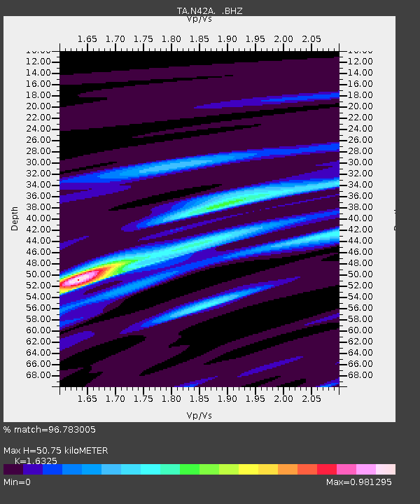
| Estimated Moho Depth: |
50.75 km |
| Estimated Crust Vp/Vs: |
1.63 |
| Assumed Crust Vp: |
6.498 km/s |
| Estimated Crust Vs: |
3.98 km/s |
| Estimated Crust Poisson's Ratio: |
0.20 |
|
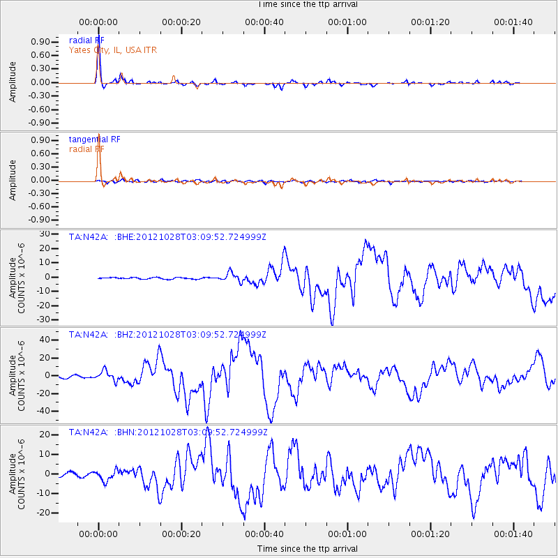
| Radial Match: |
96.783005 % |
| Radial Bump: |
233 |
| Transverse Match: |
77.43652 % |
| Transverse Bump: |
400 |
| SOD ConfigId: |
478790 |
| Insert Time: |
2013-03-01 08:42:10.141 +0000 |
| GWidth: |
2.5 |
| Max Bumps: |
400 |
| Tol: |
0.001 |
|
Signal To Noise
| Channel | StoN | STA | LTA |
| TA:N42A: :BHZ:20121028T03:09:52.724999Z | 5.8880987 | 5.665583E-6 | 9.622092E-7 |
| TA:N42A: :BHN:20121028T03:09:52.724999Z | 3.9191012 | 2.7290555E-6 | 6.963473E-7 |
| TA:N42A: :BHE:20121028T03:09:52.724999Z | 5.879155 | 3.22431E-6 | 5.484308E-7 |
| Arrivals |
| Ps | 5.4 SECOND |
| PpPs | 19 SECOND |
| PsPs/PpSs | 24 SECOND |


