You are here: Home > Network List > TA - USArray Transportable Network (new EarthScope stations) Stations List
> Station E45A Wooded Hills, Hulbert, MI, USA > Earthquake Result Viewer
E45A Wooded Hills, Hulbert, MI, USA - Earthquake Result Viewer
| Earthquake location: |
Queen Charlotte Islands Region |
| Earthquake latitude/longitude: |
52.8/-132.1 |
| Earthquake time(UTC): |
2012/10/28 (302) 03:04:08 GMT |
| Earthquake Depth: |
14 km |
| Earthquake Magnitude: |
6.5 MB, 7.5 MS, 7.8 MW, 7.8 MW |
| Earthquake Catalog/Contributor: |
WHDF/NEIC |
|
| Network: |
TA USArray Transportable Network (new EarthScope stations) |
| Station: |
E45A Wooded Hills, Hulbert, MI, USA |
| Lat/Lon: |
46.36 N/85.18 W |
| Elevation: |
251 m |
|
| Distance: |
30.6 deg |
| Az: |
82.979 deg |
| Baz: |
299.503 deg |
| Ray Param: |
0.07927266 |
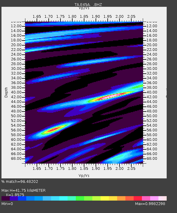
| Estimated Moho Depth: |
41.75 km |
| Estimated Crust Vp/Vs: |
1.96 |
| Assumed Crust Vp: |
6.467 km/s |
| Estimated Crust Vs: |
3.304 km/s |
| Estimated Crust Poisson's Ratio: |
0.32 |
|
| Radial Match: |
96.48202 % |
| Radial Bump: |
270 |
| Transverse Match: |
78.86772 % |
| Transverse Bump: |
400 |
| SOD ConfigId: |
478790 |
| Insert Time: |
2013-03-01 08:42:28.190 +0000 |
| GWidth: |
2.5 |
| Max Bumps: |
400 |
| Tol: |
0.001 |
|

Signal To Noise
| Channel | StoN | STA | LTA |
| TA:E45A: :BHZ:20121028T03:09:51.950005Z | 5.7798514 | 4.5512406E-6 | 7.8743216E-7 |
| TA:E45A: :BHN:20121028T03:09:51.950005Z | 1.4353498 | 1.7142645E-6 | 1.1943183E-6 |
| TA:E45A: :BHE:20121028T03:09:51.950005Z | 2.4906871 | 2.3469452E-6 | 9.4228824E-7 |
| Arrivals |
| Ps | 6.7 SECOND |
| PpPs | 18 SECOND |
| PsPs/PpSs | 24 SECOND |


