You are here: Home > Network List > TA - USArray Transportable Network (new EarthScope stations) Stations List
> Station P47A Martinsville, IN, USA > Earthquake Result Viewer
P47A Martinsville, IN, USA - Earthquake Result Viewer

| Earthquake location: |
Queen Charlotte Islands Region |
| Earthquake latitude/longitude: |
52.8/-132.1 |
| Earthquake time(UTC): |
2012/10/28 (302) 03:04:08 GMT |
| Earthquake Depth: |
14 km |
| Earthquake Magnitude: |
6.5 MB, 7.5 MS, 7.8 MW, 7.8 MW |
| Earthquake Catalog/Contributor: |
WHDF/NEIC |
|
| Network: |
TA USArray Transportable Network (new EarthScope stations) |
| Station: |
P47A Martinsville, IN, USA |
| Lat/Lon: |
39.49 N/86.27 W |
| Elevation: |
246 m |
|
| Distance: |
33.8 deg |
| Az: |
94.501 deg |
| Baz: |
308.519 deg |
| Ray Param: |
0.07801623 |
| Estimated Moho Depth: |
34.0 km |
| Estimated Crust Vp/Vs: |
2.04 |
| Assumed Crust Vp: |
6.444 km/s |
| Estimated Crust Vs: |
3.167 km/s |
| Estimated Crust Poisson's Ratio: |
0.34 |
|
| Radial Match: |
95.3375 % |
| Radial Bump: |
322 |
| Transverse Match: |
80.6375 % |
| Transverse Bump: |
400 |
| SOD ConfigId: |
478790 |
| Insert Time: |
2013-03-01 08:43:35.407 +0000 |
| GWidth: |
2.5 |
| Max Bumps: |
400 |
| Tol: |
0.001 |
|
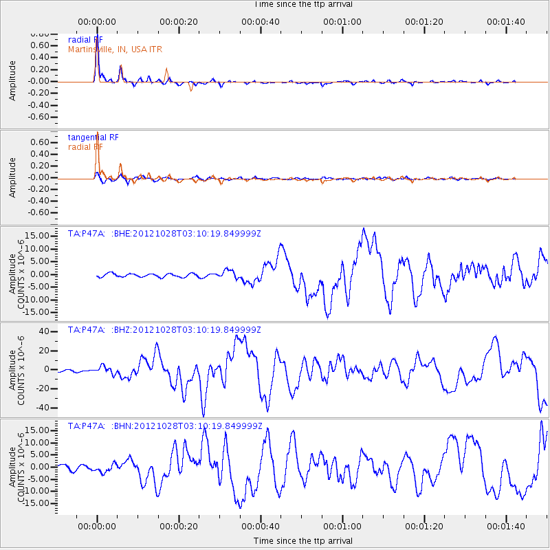
Signal To Noise
| Channel | StoN | STA | LTA |
| TA:P47A: :BHZ:20121028T03:10:19.849999Z | 3.8723032 | 3.966755E-6 | 1.0243916E-6 |
| TA:P47A: :BHN:20121028T03:10:19.849999Z | 1.5135676 | 1.6549978E-6 | 1.0934417E-6 |
| TA:P47A: :BHE:20121028T03:10:19.849999Z | 2.451111 | 1.607399E-6 | 6.557838E-7 |
| Arrivals |
| Ps | 5.8 SECOND |
| PpPs | 15 SECOND |
| PsPs/PpSs | 21 SECOND |


