You are here: Home > Network List > TA - USArray Transportable Network (new EarthScope stations) Stations List
> Station O47A Sheridan, IN, USA > Earthquake Result Viewer
O47A Sheridan, IN, USA - Earthquake Result Viewer
| Earthquake location: |
Queen Charlotte Islands Region |
| Earthquake latitude/longitude: |
52.8/-132.1 |
| Earthquake time(UTC): |
2012/10/28 (302) 03:04:08 GMT |
| Earthquake Depth: |
14 km |
| Earthquake Magnitude: |
6.5 MB, 7.5 MS, 7.8 MW, 7.8 MW |
| Earthquake Catalog/Contributor: |
WHDF/NEIC |
|
| Network: |
TA USArray Transportable Network (new EarthScope stations) |
| Station: |
O47A Sheridan, IN, USA |
| Lat/Lon: |
40.24 N/86.17 W |
| Elevation: |
278 m |
|
| Distance: |
33.4 deg |
| Az: |
93.356 deg |
| Baz: |
307.627 deg |
| Ray Param: |
0.07820217 |
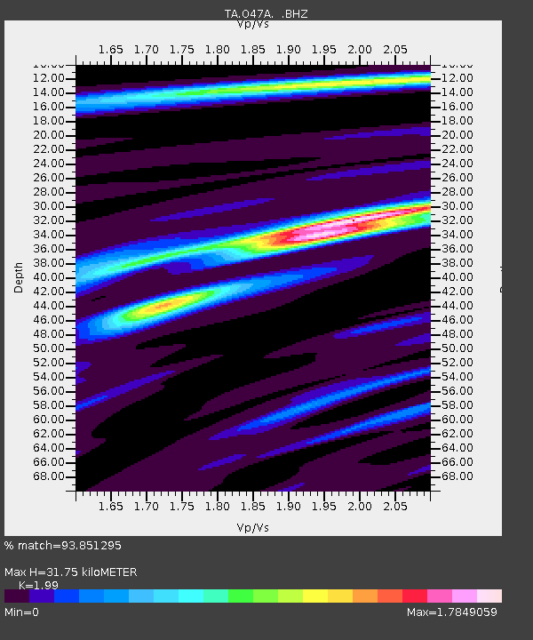
| Estimated Moho Depth: |
31.75 km |
| Estimated Crust Vp/Vs: |
1.99 |
| Assumed Crust Vp: |
6.498 km/s |
| Estimated Crust Vs: |
3.265 km/s |
| Estimated Crust Poisson's Ratio: |
0.33 |
|
| Radial Match: |
93.851295 % |
| Radial Bump: |
280 |
| Transverse Match: |
65.11141 % |
| Transverse Bump: |
400 |
| SOD ConfigId: |
478790 |
| Insert Time: |
2013-03-01 08:43:46.572 +0000 |
| GWidth: |
2.5 |
| Max Bumps: |
400 |
| Tol: |
0.001 |
|
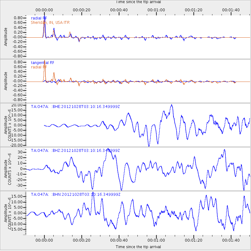
Signal To Noise
| Channel | StoN | STA | LTA |
| TA:O47A: :BHZ:20121028T03:10:16.349999Z | 3.0550413 | 3.6972513E-6 | 1.2102132E-6 |
| TA:O47A: :BHN:20121028T03:10:16.349999Z | 1.6612191 | 1.681924E-6 | 1.0124637E-6 |
| TA:O47A: :BHE:20121028T03:10:16.349999Z | 2.956277 | 2.2766305E-6 | 7.701006E-7 |
| Arrivals |
| Ps | 5.2 SECOND |
| PpPs | 14 SECOND |
| PsPs/PpSs | 19 SECOND |


