You are here: Home > Network List > G - GEOSCOPE Stations List
> Station WUS Wushi, Xinjiang Uygur, China > Earthquake Result Viewer
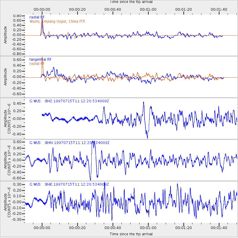
WUS Wushi, Xinjiang Uygur, China - Earthquake Result Viewer
*The percent match for this event was below the threshold and hence no stack was calculated.
| Earthquake location: |
Taiwan Region |
| Earthquake latitude/longitude: |
24.7/122.4 |
| Earthquake time(UTC): |
1997/07/15 (196) 11:05:31 GMT |
| Earthquake Depth: |
103 km |
| Earthquake Magnitude: |
5.6 MB, 5.6 UNKNOWN, 5.6 MW |
| Earthquake Catalog/Contributor: |
WHDF/NEIC |
|
| Network: |
G GEOSCOPE |
| Station: |
WUS Wushi, Xinjiang Uygur, China |
| Lat/Lon: |
41.20 N/79.22 E |
| Elevation: |
1457 m |
|
| Distance: |
39.4 deg |
| Az: |
305.466 deg |
| Baz: |
101.002 deg |
| Ray Param: |
$rayparam |
*The percent match for this event was below the threshold and hence was not used in the summary stack. |
|
| Radial Match: |
77.5436 % |
| Radial Bump: |
400 |
| Transverse Match: |
47.978386 % |
| Transverse Bump: |
400 |
| SOD ConfigId: |
4480 |
| Insert Time: |
2010-02-27 01:08:17.827 +0000 |
| GWidth: |
2.5 |
| Max Bumps: |
400 |
| Tol: |
0.001 |
|
Signal To Noise
| Channel | StoN | STA | LTA |
| G:WUS: :BHN:19970715T11:12:20.534009Z | 1.3233635 | 1.324027E-7 | 1.0005014E-7 |
| G:WUS: :BHE:19970715T11:12:20.534009Z | 0.95316786 | 7.08658E-8 | 7.434767E-8 |
| G:WUS: :BHZ:19970715T11:12:20.534009Z | 1.5030506 | 8.876579E-8 | 5.905709E-8 |
| Arrivals |
| Ps | |
| PpPs | |
| PsPs/PpSs | |


