You are here: Home > Network List > TA - USArray Transportable Network (new EarthScope stations) Stations List
> Station P45A Graceland, Paris, IL, USA > Earthquake Result Viewer
P45A Graceland, Paris, IL, USA - Earthquake Result Viewer

| Earthquake location: |
Queen Charlotte Islands Region |
| Earthquake latitude/longitude: |
52.8/-132.1 |
| Earthquake time(UTC): |
2012/10/28 (302) 03:04:08 GMT |
| Earthquake Depth: |
14 km |
| Earthquake Magnitude: |
6.5 MB, 7.5 MS, 7.8 MW, 7.8 MW |
| Earthquake Catalog/Contributor: |
WHDF/NEIC |
|
| Network: |
TA USArray Transportable Network (new EarthScope stations) |
| Station: |
P45A Graceland, Paris, IL, USA |
| Lat/Lon: |
39.53 N/87.74 W |
| Elevation: |
193 m |
|
| Distance: |
32.9 deg |
| Az: |
95.736 deg |
| Baz: |
308.616 deg |
| Ray Param: |
0.07843894 |
| Estimated Moho Depth: |
54.0 km |
| Estimated Crust Vp/Vs: |
1.70 |
| Assumed Crust Vp: |
6.444 km/s |
| Estimated Crust Vs: |
3.785 km/s |
| Estimated Crust Poisson's Ratio: |
0.24 |
|
| Radial Match: |
95.03206 % |
| Radial Bump: |
228 |
| Transverse Match: |
65.231834 % |
| Transverse Bump: |
400 |
| SOD ConfigId: |
478790 |
| Insert Time: |
2013-03-01 08:44:43.292 +0000 |
| GWidth: |
2.5 |
| Max Bumps: |
400 |
| Tol: |
0.001 |
|
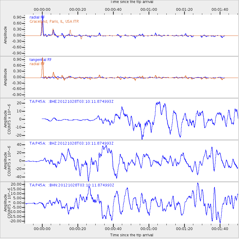
Signal To Noise
| Channel | StoN | STA | LTA |
| TA:P45A: :BHZ:20121028T03:10:11.874993Z | 4.20606 | 3.533603E-6 | 8.401219E-7 |
| TA:P45A: :BHN:20121028T03:10:11.874993Z | 4.7917414 | 2.3343443E-6 | 4.871599E-7 |
| TA:P45A: :BHE:20121028T03:10:11.874993Z | 3.0920227 | 2.4757978E-6 | 8.007049E-7 |
| Arrivals |
| Ps | 6.4 SECOND |
| PpPs | 21 SECOND |
| PsPs/PpSs | 27 SECOND |


