You are here: Home > Network List > TA - USArray Transportable Network (new EarthScope stations) Stations List
> Station S48A Wiedeman Farm, Cecilia, KY, USA > Earthquake Result Viewer
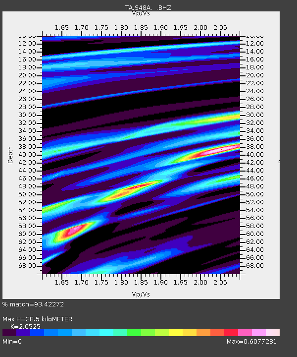
S48A Wiedeman Farm, Cecilia, KY, USA - Earthquake Result Viewer
| Earthquake location: |
Queen Charlotte Islands Region |
| Earthquake latitude/longitude: |
52.8/-132.1 |
| Earthquake time(UTC): |
2012/10/28 (302) 03:04:08 GMT |
| Earthquake Depth: |
14 km |
| Earthquake Magnitude: |
6.5 MB, 7.5 MS, 7.8 MW, 7.8 MW |
| Earthquake Catalog/Contributor: |
WHDF/NEIC |
|
| Network: |
TA USArray Transportable Network (new EarthScope stations) |
| Station: |
S48A Wiedeman Farm, Cecilia, KY, USA |
| Lat/Lon: |
37.66 N/86.06 W |
| Elevation: |
238 m |
|
| Distance: |
35.1 deg |
| Az: |
96.803 deg |
| Baz: |
310.548 deg |
| Ray Param: |
0.077376306 |
| Estimated Moho Depth: |
38.5 km |
| Estimated Crust Vp/Vs: |
2.05 |
| Assumed Crust Vp: |
6.444 km/s |
| Estimated Crust Vs: |
3.14 km/s |
| Estimated Crust Poisson's Ratio: |
0.34 |
|
| Radial Match: |
93.42272 % |
| Radial Bump: |
262 |
| Transverse Match: |
79.837715 % |
| Transverse Bump: |
400 |
| SOD ConfigId: |
478790 |
| Insert Time: |
2013-03-01 08:45:21.628 +0000 |
| GWidth: |
2.5 |
| Max Bumps: |
400 |
| Tol: |
0.001 |
|

Signal To Noise
| Channel | StoN | STA | LTA |
| TA:S48A: :BHZ:20121028T03:10:30.999993Z | 4.149715 | 5.8432192E-6 | 1.4081014E-6 |
| TA:S48A: :BHN:20121028T03:10:30.999993Z | 2.538088 | 1.8370721E-6 | 7.238015E-7 |
| TA:S48A: :BHE:20121028T03:10:30.999993Z | 3.62903 | 2.3979503E-6 | 6.6076893E-7 |
| Arrivals |
| Ps | 6.7 SECOND |
| PpPs | 17 SECOND |
| PsPs/PpSs | 24 SECOND |


