You are here: Home > Network List > TA - USArray Transportable Network (new EarthScope stations) Stations List
> Station R48A Northridge Ranch, Floyd Knobs, IN, USA > Earthquake Result Viewer
R48A Northridge Ranch, Floyd Knobs, IN, USA - Earthquake Result Viewer
| Earthquake location: |
Queen Charlotte Islands Region |
| Earthquake latitude/longitude: |
52.8/-132.1 |
| Earthquake time(UTC): |
2012/10/28 (302) 03:04:08 GMT |
| Earthquake Depth: |
14 km |
| Earthquake Magnitude: |
6.5 MB, 7.5 MS, 7.8 MW, 7.8 MW |
| Earthquake Catalog/Contributor: |
WHDF/NEIC |
|
| Network: |
TA USArray Transportable Network (new EarthScope stations) |
| Station: |
R48A Northridge Ranch, Floyd Knobs, IN, USA |
| Lat/Lon: |
38.40 N/85.87 W |
| Elevation: |
243 m |
|
| Distance: |
34.8 deg |
| Az: |
95.648 deg |
| Baz: |
309.716 deg |
| Ray Param: |
0.07756548 |
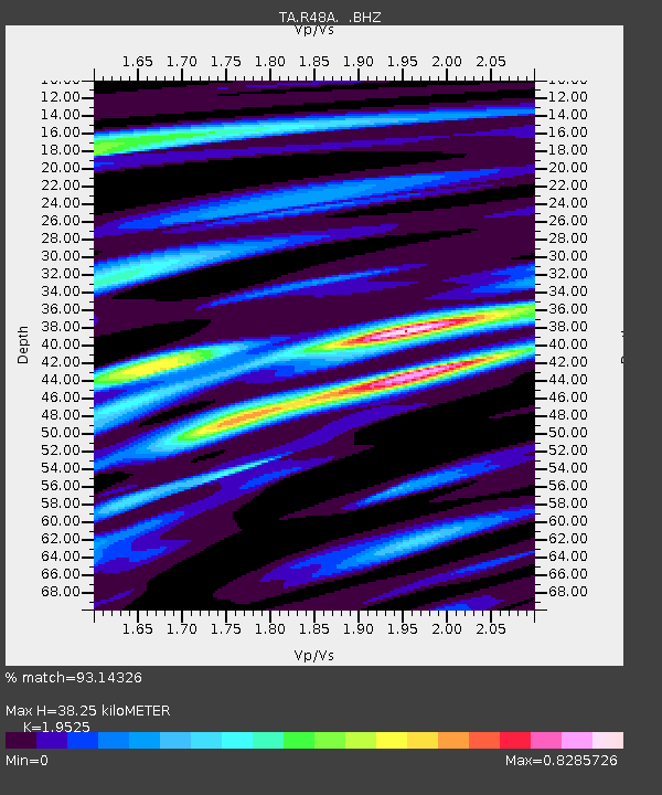
| Estimated Moho Depth: |
38.25 km |
| Estimated Crust Vp/Vs: |
1.95 |
| Assumed Crust Vp: |
6.498 km/s |
| Estimated Crust Vs: |
3.328 km/s |
| Estimated Crust Poisson's Ratio: |
0.32 |
|
| Radial Match: |
93.14326 % |
| Radial Bump: |
342 |
| Transverse Match: |
79.72877 % |
| Transverse Bump: |
400 |
| SOD ConfigId: |
478790 |
| Insert Time: |
2013-03-01 08:45:33.694 +0000 |
| GWidth: |
2.5 |
| Max Bumps: |
400 |
| Tol: |
0.001 |
|

Signal To Noise
| Channel | StoN | STA | LTA |
| TA:R48A: :BHZ:20121028T03:10:27.825005Z | 3.074645 | 4.1388694E-6 | 1.3461291E-6 |
| TA:R48A: :BHN:20121028T03:10:27.825005Z | 2.1276507 | 1.4723668E-6 | 6.920152E-7 |
| TA:R48A: :BHE:20121028T03:10:27.825005Z | 2.7192454 | 2.1544943E-6 | 7.9231336E-7 |
| Arrivals |
| Ps | 6.0 SECOND |
| PpPs | 16 SECOND |
| PsPs/PpSs | 22 SECOND |


