You are here: Home > Network List > TA - USArray Transportable Network (new EarthScope stations) Stations List
> Station X47A Russelville, AR, USA > Earthquake Result Viewer
X47A Russelville, AR, USA - Earthquake Result Viewer
| Earthquake location: |
Queen Charlotte Islands Region |
| Earthquake latitude/longitude: |
52.8/-132.1 |
| Earthquake time(UTC): |
2012/10/28 (302) 03:04:08 GMT |
| Earthquake Depth: |
14 km |
| Earthquake Magnitude: |
6.5 MB, 7.5 MS, 7.8 MW, 7.8 MW |
| Earthquake Catalog/Contributor: |
WHDF/NEIC |
|
| Network: |
TA USArray Transportable Network (new EarthScope stations) |
| Station: |
X47A Russelville, AR, USA |
| Lat/Lon: |
34.52 N/87.86 W |
| Elevation: |
212 m |
|
| Distance: |
36.2 deg |
| Az: |
102.464 deg |
| Baz: |
314.095 deg |
| Ray Param: |
0.076822996 |
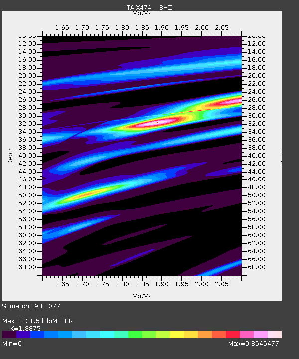
| Estimated Moho Depth: |
31.5 km |
| Estimated Crust Vp/Vs: |
1.89 |
| Assumed Crust Vp: |
6.476 km/s |
| Estimated Crust Vs: |
3.431 km/s |
| Estimated Crust Poisson's Ratio: |
0.30 |
|
| Radial Match: |
93.1077 % |
| Radial Bump: |
289 |
| Transverse Match: |
68.13555 % |
| Transverse Bump: |
400 |
| SOD ConfigId: |
478790 |
| Insert Time: |
2013-03-01 08:45:36.947 +0000 |
| GWidth: |
2.5 |
| Max Bumps: |
400 |
| Tol: |
0.001 |
|

Signal To Noise
| Channel | StoN | STA | LTA |
| TA:X47A: :BHZ:20121028T03:10:39.825005Z | 1.706457 | 2.1867877E-6 | 1.2814784E-6 |
| TA:X47A: :BHN:20121028T03:10:39.825005Z | 1.9028434 | 1.1066555E-6 | 5.815799E-7 |
| TA:X47A: :BHE:20121028T03:10:39.825005Z | 1.3274494 | 1.489391E-6 | 1.1219946E-6 |
| Arrivals |
| Ps | 4.6 SECOND |
| PpPs | 13 SECOND |
| PsPs/PpSs | 18 SECOND |


