You are here: Home > Network List > G - GEOSCOPE Stations List
> Station WUS Wushi, Xinjiang Uygur, China > Earthquake Result Viewer
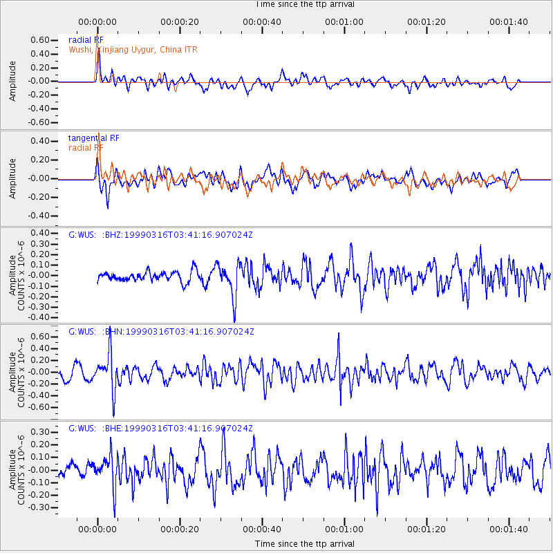
WUS Wushi, Xinjiang Uygur, China - Earthquake Result Viewer
*The percent match for this event was below the threshold and hence no stack was calculated.
| Earthquake location: |
Talaud Islands, Indonesia |
| Earthquake latitude/longitude: |
2.7/125.7 |
| Earthquake time(UTC): |
1999/03/16 (075) 03:32:16 GMT |
| Earthquake Depth: |
114 km |
| Earthquake Magnitude: |
5.6 MB |
| Earthquake Catalog/Contributor: |
WHDF/NEIC |
|
| Network: |
G GEOSCOPE |
| Station: |
WUS Wushi, Xinjiang Uygur, China |
| Lat/Lon: |
41.20 N/79.22 E |
| Elevation: |
1457 m |
|
| Distance: |
56.6 deg |
| Az: |
319.093 deg |
| Baz: |
119.907 deg |
| Ray Param: |
$rayparam |
*The percent match for this event was below the threshold and hence was not used in the summary stack. |
|
| Radial Match: |
66.90286 % |
| Radial Bump: |
400 |
| Transverse Match: |
52.649086 % |
| Transverse Bump: |
400 |
| SOD ConfigId: |
4480 |
| Insert Time: |
2010-02-27 01:08:26.903 +0000 |
| GWidth: |
2.5 |
| Max Bumps: |
400 |
| Tol: |
0.001 |
|
Signal To Noise
| Channel | StoN | STA | LTA |
| G:WUS: :BHN:19990316T03:41:16.907024Z | 3.6781359 | 3.1192982E-7 | 8.4806494E-8 |
| G:WUS: :BHE:19990316T03:41:16.907024Z | 1.562548 | 1.3977602E-7 | 8.94539E-8 |
| G:WUS: :BHZ:19990316T03:41:16.907024Z | 3.4463458 | 1.5909133E-7 | 4.6162324E-8 |
| Arrivals |
| Ps | |
| PpPs | |
| PsPs/PpSs | |


