You are here: Home > Network List > TA - USArray Transportable Network (new EarthScope stations) Stations List
> Station 249A Camden, AL, USA > Earthquake Result Viewer
249A Camden, AL, USA - Earthquake Result Viewer
| Earthquake location: |
Queen Charlotte Islands Region |
| Earthquake latitude/longitude: |
52.8/-132.1 |
| Earthquake time(UTC): |
2012/10/28 (302) 03:04:08 GMT |
| Earthquake Depth: |
14 km |
| Earthquake Magnitude: |
6.5 MB, 7.5 MS, 7.8 MW, 7.8 MW |
| Earthquake Catalog/Contributor: |
WHDF/NEIC |
|
| Network: |
TA USArray Transportable Network (new EarthScope stations) |
| Station: |
249A Camden, AL, USA |
| Lat/Lon: |
31.98 N/87.12 W |
| Elevation: |
66 m |
|
| Distance: |
38.4 deg |
| Az: |
104.694 deg |
| Baz: |
316.27 deg |
| Ray Param: |
0.07557843 |
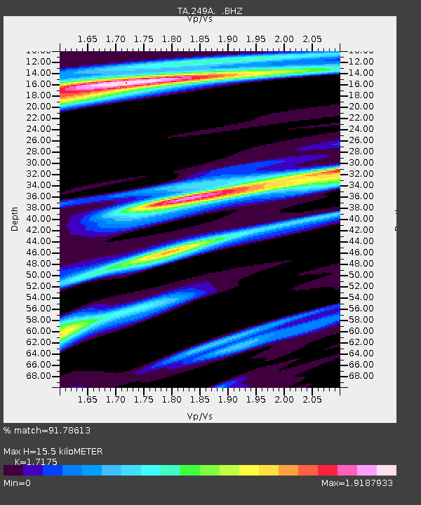
| Estimated Moho Depth: |
15.5 km |
| Estimated Crust Vp/Vs: |
1.72 |
| Assumed Crust Vp: |
6.187 km/s |
| Estimated Crust Vs: |
3.602 km/s |
| Estimated Crust Poisson's Ratio: |
0.24 |
|
| Radial Match: |
91.78613 % |
| Radial Bump: |
302 |
| Transverse Match: |
72.35601 % |
| Transverse Bump: |
400 |
| SOD ConfigId: |
478790 |
| Insert Time: |
2013-03-01 08:47:02.734 +0000 |
| GWidth: |
2.5 |
| Max Bumps: |
400 |
| Tol: |
0.001 |
|
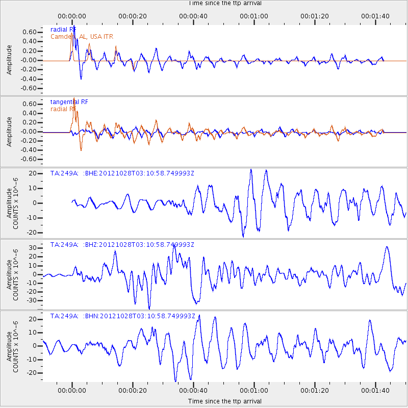
Signal To Noise
| Channel | StoN | STA | LTA |
| TA:249A: :BHZ:20121028T03:10:58.749993Z | 6.5668826 | 4.2370652E-6 | 6.452172E-7 |
| TA:249A: :BHN:20121028T03:10:58.749993Z | 1.0257632 | 2.2635775E-6 | 2.2067252E-6 |
| TA:249A: :BHE:20121028T03:10:58.749993Z | 0.5384652 | 1.4055955E-6 | 2.6103737E-6 |
| Arrivals |
| Ps | 1.9 SECOND |
| PpPs | 6.4 SECOND |
| PsPs/PpSs | 8.3 SECOND |


