You are here: Home > Network List > TA - USArray Transportable Network (new EarthScope stations) Stations List
> Station 251A Midway, AL, USA > Earthquake Result Viewer
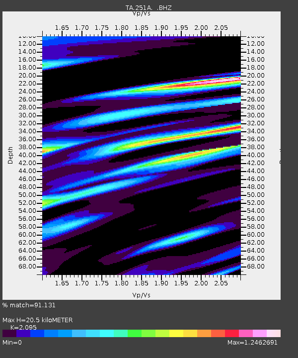
251A Midway, AL, USA - Earthquake Result Viewer
| Earthquake location: |
Queen Charlotte Islands Region |
| Earthquake latitude/longitude: |
52.8/-132.1 |
| Earthquake time(UTC): |
2012/10/28 (302) 03:04:08 GMT |
| Earthquake Depth: |
14 km |
| Earthquake Magnitude: |
6.5 MB, 7.5 MS, 7.8 MW, 7.8 MW |
| Earthquake Catalog/Contributor: |
WHDF/NEIC |
|
| Network: |
TA USArray Transportable Network (new EarthScope stations) |
| Station: |
251A Midway, AL, USA |
| Lat/Lon: |
32.09 N/85.41 W |
| Elevation: |
139 m |
|
| Distance: |
39.3 deg |
| Az: |
102.895 deg |
| Baz: |
315.774 deg |
| Ray Param: |
0.07504353 |
| Estimated Moho Depth: |
20.5 km |
| Estimated Crust Vp/Vs: |
2.10 |
| Assumed Crust Vp: |
6.719 km/s |
| Estimated Crust Vs: |
3.207 km/s |
| Estimated Crust Poisson's Ratio: |
0.35 |
|
| Radial Match: |
91.131 % |
| Radial Bump: |
400 |
| Transverse Match: |
61.79691 % |
| Transverse Bump: |
400 |
| SOD ConfigId: |
478790 |
| Insert Time: |
2013-03-01 08:47:17.101 +0000 |
| GWidth: |
2.5 |
| Max Bumps: |
400 |
| Tol: |
0.001 |
|

Signal To Noise
| Channel | StoN | STA | LTA |
| TA:251A: :BHZ:20121028T03:11:06.499993Z | 2.8989966 | 3.1020172E-6 | 1.0700313E-6 |
| TA:251A: :BHN:20121028T03:11:06.499993Z | 1.2715095 | 2.4495928E-6 | 1.9265233E-6 |
| TA:251A: :BHE:20121028T03:11:06.499993Z | 0.56271243 | 1.2721655E-6 | 2.2607737E-6 |
| Arrivals |
| Ps | 3.6 SECOND |
| PpPs | 8.8 SECOND |
| PsPs/PpSs | 12 SECOND |


