You are here: Home > Network List > TA - USArray Transportable Network (new EarthScope stations) Stations List
> Station 352A Blakely, GA, USA > Earthquake Result Viewer
352A Blakely, GA, USA - Earthquake Result Viewer

| Earthquake location: |
Queen Charlotte Islands Region |
| Earthquake latitude/longitude: |
52.8/-132.1 |
| Earthquake time(UTC): |
2012/10/28 (302) 03:04:08 GMT |
| Earthquake Depth: |
14 km |
| Earthquake Magnitude: |
6.5 MB, 7.5 MS, 7.8 MW, 7.8 MW |
| Earthquake Catalog/Contributor: |
WHDF/NEIC |
|
| Network: |
TA USArray Transportable Network (new EarthScope stations) |
| Station: |
352A Blakely, GA, USA |
| Lat/Lon: |
31.48 N/84.93 W |
| Elevation: |
101 m |
|
| Distance: |
40.0 deg |
| Az: |
103.099 deg |
| Baz: |
316.183 deg |
| Ray Param: |
0.07461302 |
| Estimated Moho Depth: |
17.25 km |
| Estimated Crust Vp/Vs: |
1.80 |
| Assumed Crust Vp: |
6.347 km/s |
| Estimated Crust Vs: |
3.521 km/s |
| Estimated Crust Poisson's Ratio: |
0.28 |
|
| Radial Match: |
83.55754 % |
| Radial Bump: |
311 |
| Transverse Match: |
55.317135 % |
| Transverse Bump: |
400 |
| SOD ConfigId: |
478790 |
| Insert Time: |
2013-03-01 08:48:16.407 +0000 |
| GWidth: |
2.5 |
| Max Bumps: |
400 |
| Tol: |
0.001 |
|
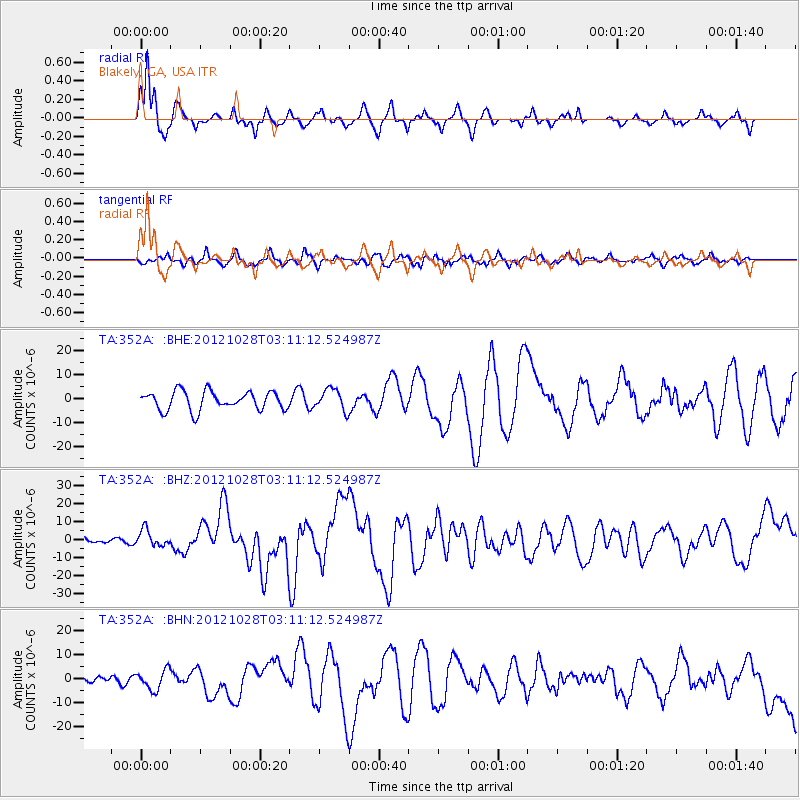
Signal To Noise
| Channel | StoN | STA | LTA |
| TA:352A: :BHZ:20121028T03:11:12.524987Z | 2.4111395 | 4.579277E-6 | 1.8992171E-6 |
| TA:352A: :BHN:20121028T03:11:12.524987Z | 0.75485414 | 4.0645828E-6 | 5.3845934E-6 |
| TA:352A: :BHE:20121028T03:11:12.524987Z | 1.1339146 | 4.417431E-6 | 3.895735E-6 |
| Arrivals |
| Ps | 2.3 SECOND |
| PpPs | 7.1 SECOND |
| PsPs/PpSs | 9.5 SECOND |


