You are here: Home > Network List > TA - USArray Transportable Network (new EarthScope stations) Stations List
> Station 153A Fort Valley, GA, USA > Earthquake Result Viewer
153A Fort Valley, GA, USA - Earthquake Result Viewer
| Earthquake location: |
Queen Charlotte Islands Region |
| Earthquake latitude/longitude: |
52.8/-132.1 |
| Earthquake time(UTC): |
2012/10/28 (302) 03:04:08 GMT |
| Earthquake Depth: |
14 km |
| Earthquake Magnitude: |
6.5 MB, 7.5 MS, 7.8 MW, 7.8 MW |
| Earthquake Catalog/Contributor: |
WHDF/NEIC |
|
| Network: |
TA USArray Transportable Network (new EarthScope stations) |
| Station: |
153A Fort Valley, GA, USA |
| Lat/Lon: |
32.66 N/83.83 W |
| Elevation: |
160 m |
|
| Distance: |
39.9 deg |
| Az: |
100.781 deg |
| Baz: |
314.985 deg |
| Ray Param: |
0.07473013 |
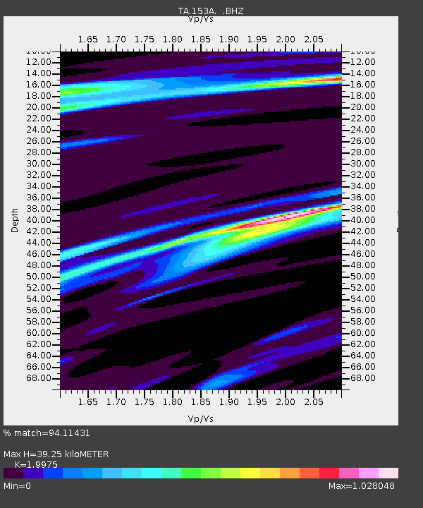
| Estimated Moho Depth: |
39.25 km |
| Estimated Crust Vp/Vs: |
2.00 |
| Assumed Crust Vp: |
6.565 km/s |
| Estimated Crust Vs: |
3.286 km/s |
| Estimated Crust Poisson's Ratio: |
0.33 |
|
| Radial Match: |
94.11431 % |
| Radial Bump: |
269 |
| Transverse Match: |
66.00272 % |
| Transverse Bump: |
400 |
| SOD ConfigId: |
478790 |
| Insert Time: |
2013-03-01 08:48:46.372 +0000 |
| GWidth: |
2.5 |
| Max Bumps: |
400 |
| Tol: |
0.001 |
|

Signal To Noise
| Channel | StoN | STA | LTA |
| TA:153A: :BHZ:20121028T03:11:10.950005Z | 2.1841812 | 4.0408195E-6 | 1.8500386E-6 |
| TA:153A: :BHN:20121028T03:11:10.950005Z | 1.9797807 | 1.4593238E-6 | 7.3711385E-7 |
| TA:153A: :BHE:20121028T03:11:10.950005Z | 1.404334 | 2.3514865E-6 | 1.6744497E-6 |
| Arrivals |
| Ps | 6.4 SECOND |
| PpPs | 17 SECOND |
| PsPs/PpSs | 23 SECOND |


