You are here: Home > Network List > TA - USArray Transportable Network (new EarthScope stations) Stations List
> Station Y51A Rockmart, GA, USA > Earthquake Result Viewer
Y51A Rockmart, GA, USA - Earthquake Result Viewer
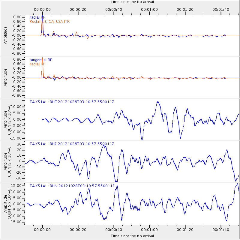
| Earthquake location: |
Queen Charlotte Islands Region |
| Earthquake latitude/longitude: |
52.8/-132.1 |
| Earthquake time(UTC): |
2012/10/28 (302) 03:04:08 GMT |
| Earthquake Depth: |
14 km |
| Earthquake Magnitude: |
6.5 MB, 7.5 MS, 7.8 MW, 7.8 MW |
| Earthquake Catalog/Contributor: |
WHDF/NEIC |
|
| Network: |
TA USArray Transportable Network (new EarthScope stations) |
| Station: |
Y51A Rockmart, GA, USA |
| Lat/Lon: |
33.90 N/85.06 W |
| Elevation: |
380 m |
|
| Distance: |
38.3 deg |
| Az: |
100.532 deg |
| Baz: |
314.119 deg |
| Ray Param: |
0.07566009 |
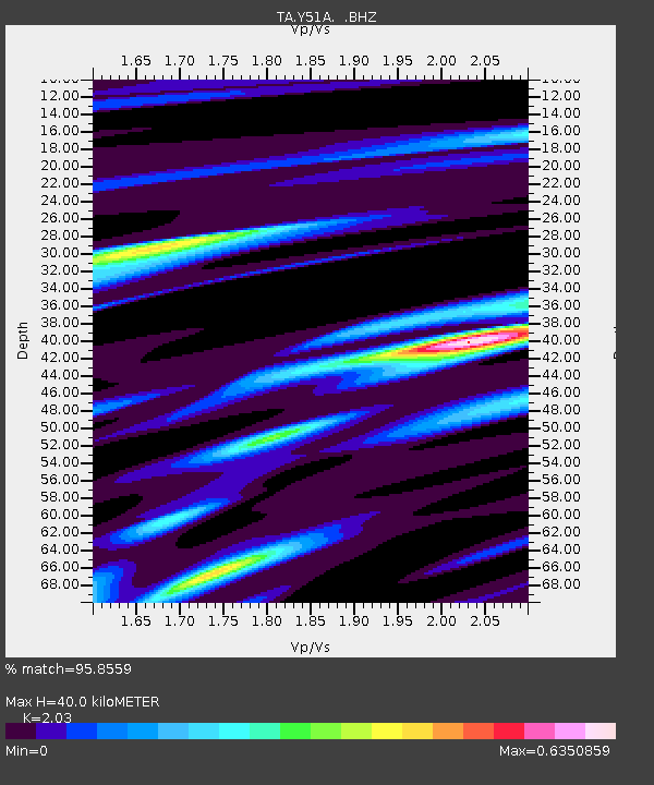
| Estimated Moho Depth: |
40.0 km |
| Estimated Crust Vp/Vs: |
2.03 |
| Assumed Crust Vp: |
6.719 km/s |
| Estimated Crust Vs: |
3.31 km/s |
| Estimated Crust Poisson's Ratio: |
0.34 |
|
| Radial Match: |
95.8559 % |
| Radial Bump: |
284 |
| Transverse Match: |
75.85674 % |
| Transverse Bump: |
400 |
| SOD ConfigId: |
478790 |
| Insert Time: |
2013-03-01 08:49:20.691 +0000 |
| GWidth: |
2.5 |
| Max Bumps: |
400 |
| Tol: |
0.001 |
|
Signal To Noise
| Channel | StoN | STA | LTA |
| TA:Y51A: :BHZ:20121028T03:10:57.550011Z | 2.0024874 | 3.1463724E-6 | 1.571232E-6 |
| TA:Y51A: :BHN:20121028T03:10:57.550011Z | 2.2695506 | 1.580165E-6 | 6.962458E-7 |
| TA:Y51A: :BHE:20121028T03:10:57.550011Z | 2.2237184 | 2.3569426E-6 | 1.0599106E-6 |
| Arrivals |
| Ps | 6.6 SECOND |
| PpPs | 17 SECOND |
| PsPs/PpSs | 23 SECOND |


