You are here: Home > Network List > TA - USArray Transportable Network (new EarthScope stations) Stations List
> Station W52A Murphy, NC, USA > Earthquake Result Viewer
W52A Murphy, NC, USA - Earthquake Result Viewer
| Earthquake location: |
Queen Charlotte Islands Region |
| Earthquake latitude/longitude: |
52.8/-132.1 |
| Earthquake time(UTC): |
2012/10/28 (302) 03:04:08 GMT |
| Earthquake Depth: |
14 km |
| Earthquake Magnitude: |
6.5 MB, 7.5 MS, 7.8 MW, 7.8 MW |
| Earthquake Catalog/Contributor: |
WHDF/NEIC |
|
| Network: |
TA USArray Transportable Network (new EarthScope stations) |
| Station: |
W52A Murphy, NC, USA |
| Lat/Lon: |
35.09 N/83.93 W |
| Elevation: |
519 m |
|
| Distance: |
38.1 deg |
| Az: |
98.089 deg |
| Baz: |
312.839 deg |
| Ray Param: |
0.07574019 |
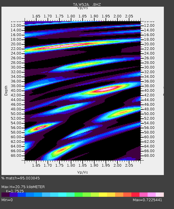
| Estimated Moho Depth: |
20.75 km |
| Estimated Crust Vp/Vs: |
1.75 |
| Assumed Crust Vp: |
6.35 km/s |
| Estimated Crust Vs: |
3.623 km/s |
| Estimated Crust Poisson's Ratio: |
0.26 |
|
| Radial Match: |
95.003845 % |
| Radial Bump: |
296 |
| Transverse Match: |
76.104866 % |
| Transverse Bump: |
400 |
| SOD ConfigId: |
478790 |
| Insert Time: |
2013-03-01 08:50:06.270 +0000 |
| GWidth: |
2.5 |
| Max Bumps: |
400 |
| Tol: |
0.001 |
|
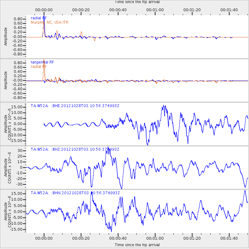
Signal To Noise
| Channel | StoN | STA | LTA |
| TA:W52A: :BHZ:20121028T03:10:56.374993Z | 2.600196 | 3.8215653E-6 | 1.4697221E-6 |
| TA:W52A: :BHN:20121028T03:10:56.374993Z | 2.320987 | 1.9694667E-6 | 8.48547E-7 |
| TA:W52A: :BHE:20121028T03:10:56.374993Z | 2.0776386 | 2.2872923E-6 | 1.1009096E-6 |
| Arrivals |
| Ps | 2.6 SECOND |
| PpPs | 8.4 SECOND |
| PsPs/PpSs | 11 SECOND |


