You are here: Home > Network List > TA - USArray Transportable Network (new EarthScope stations) Stations List
> Station W50A Signal Mountain, TN, USA > Earthquake Result Viewer
W50A Signal Mountain, TN, USA - Earthquake Result Viewer

| Earthquake location: |
Queen Charlotte Islands Region |
| Earthquake latitude/longitude: |
52.8/-132.1 |
| Earthquake time(UTC): |
2012/10/28 (302) 03:04:08 GMT |
| Earthquake Depth: |
14 km |
| Earthquake Magnitude: |
6.5 MB, 7.5 MS, 7.8 MW, 7.8 MW |
| Earthquake Catalog/Contributor: |
WHDF/NEIC |
|
| Network: |
TA USArray Transportable Network (new EarthScope stations) |
| Station: |
W50A Signal Mountain, TN, USA |
| Lat/Lon: |
35.20 N/85.31 W |
| Elevation: |
587 m |
|
| Distance: |
37.2 deg |
| Az: |
99.225 deg |
| Baz: |
312.945 deg |
| Ray Param: |
0.07625143 |
| Estimated Moho Depth: |
47.0 km |
| Estimated Crust Vp/Vs: |
1.78 |
| Assumed Crust Vp: |
6.35 km/s |
| Estimated Crust Vs: |
3.572 km/s |
| Estimated Crust Poisson's Ratio: |
0.27 |
|
| Radial Match: |
95.56871 % |
| Radial Bump: |
192 |
| Transverse Match: |
70.2645 % |
| Transverse Bump: |
400 |
| SOD ConfigId: |
478790 |
| Insert Time: |
2013-03-01 08:50:11.216 +0000 |
| GWidth: |
2.5 |
| Max Bumps: |
400 |
| Tol: |
0.001 |
|
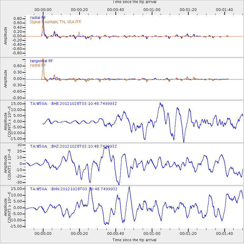
Signal To Noise
| Channel | StoN | STA | LTA |
| TA:W50A: :BHZ:20121028T03:10:48.749993Z | 3.3639066 | 4.2252213E-6 | 1.256046E-6 |
| TA:W50A: :BHN:20121028T03:10:48.749993Z | 3.71475 | 2.1461483E-6 | 5.7773696E-7 |
| TA:W50A: :BHE:20121028T03:10:48.749993Z | 2.2606244 | 2.1491867E-6 | 9.507049E-7 |
| Arrivals |
| Ps | 6.2 SECOND |
| PpPs | 19 SECOND |
| PsPs/PpSs | 25 SECOND |


