You are here: Home > Network List > TA - USArray Transportable Network (new EarthScope stations) Stations List
> Station T49A Edmonton, KY, USA > Earthquake Result Viewer
T49A Edmonton, KY, USA - Earthquake Result Viewer
| Earthquake location: |
Queen Charlotte Islands Region |
| Earthquake latitude/longitude: |
52.8/-132.1 |
| Earthquake time(UTC): |
2012/10/28 (302) 03:04:08 GMT |
| Earthquake Depth: |
14 km |
| Earthquake Magnitude: |
6.5 MB, 7.5 MS, 7.8 MW, 7.8 MW |
| Earthquake Catalog/Contributor: |
WHDF/NEIC |
|
| Network: |
TA USArray Transportable Network (new EarthScope stations) |
| Station: |
T49A Edmonton, KY, USA |
| Lat/Lon: |
37.10 N/85.53 W |
| Elevation: |
313 m |
|
| Distance: |
35.8 deg |
| Az: |
97.053 deg |
| Baz: |
311.068 deg |
| Ray Param: |
0.07701698 |
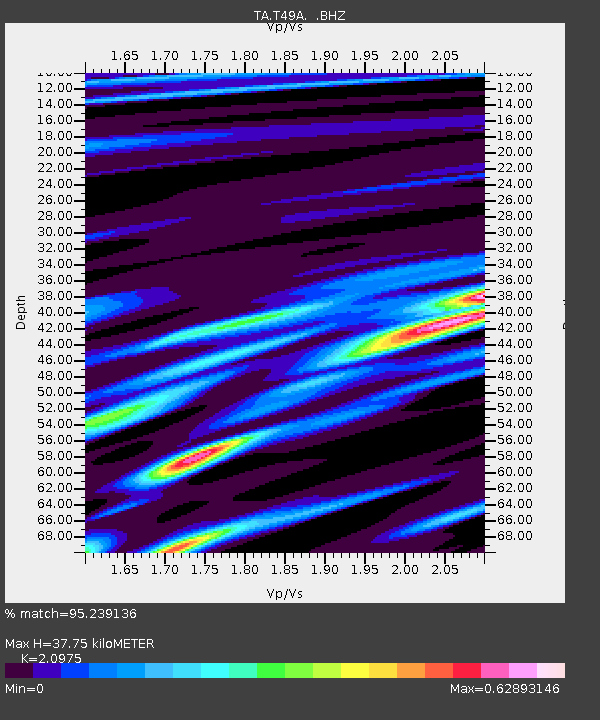
| Estimated Moho Depth: |
37.75 km |
| Estimated Crust Vp/Vs: |
2.10 |
| Assumed Crust Vp: |
6.476 km/s |
| Estimated Crust Vs: |
3.087 km/s |
| Estimated Crust Poisson's Ratio: |
0.35 |
|
| Radial Match: |
95.239136 % |
| Radial Bump: |
230 |
| Transverse Match: |
80.06437 % |
| Transverse Bump: |
400 |
| SOD ConfigId: |
478790 |
| Insert Time: |
2013-03-01 08:50:57.990 +0000 |
| GWidth: |
2.5 |
| Max Bumps: |
400 |
| Tol: |
0.001 |
|
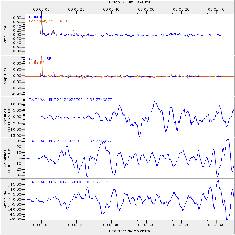
Signal To Noise
| Channel | StoN | STA | LTA |
| TA:T49A: :BHZ:20121028T03:10:36.774987Z | 2.875615 | 3.3092472E-6 | 1.1507964E-6 |
| TA:T49A: :BHN:20121028T03:10:36.774987Z | 2.5056634 | 1.2480684E-6 | 4.98099E-7 |
| TA:T49A: :BHE:20121028T03:10:36.774987Z | 3.5408382 | 2.2706104E-6 | 6.4126357E-7 |
| Arrivals |
| Ps | 6.8 SECOND |
| PpPs | 17 SECOND |
| PsPs/PpSs | 24 SECOND |


