You are here: Home > Network List > TA - USArray Transportable Network (new EarthScope stations) Stations List
> Station U50A Jamestown, TN, USA > Earthquake Result Viewer
U50A Jamestown, TN, USA - Earthquake Result Viewer
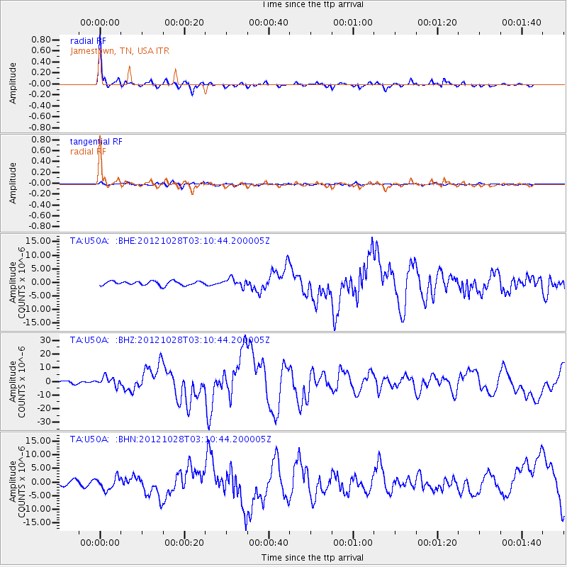
| Earthquake location: |
Queen Charlotte Islands Region |
| Earthquake latitude/longitude: |
52.8/-132.1 |
| Earthquake time(UTC): |
2012/10/28 (302) 03:04:08 GMT |
| Earthquake Depth: |
14 km |
| Earthquake Magnitude: |
6.5 MB, 7.5 MS, 7.8 MW, 7.8 MW |
| Earthquake Catalog/Contributor: |
WHDF/NEIC |
|
| Network: |
TA USArray Transportable Network (new EarthScope stations) |
| Station: |
U50A Jamestown, TN, USA |
| Lat/Lon: |
36.42 N/84.84 W |
| Elevation: |
474 m |
|
| Distance: |
36.7 deg |
| Az: |
97.306 deg |
| Baz: |
311.684 deg |
| Ray Param: |
0.07654268 |
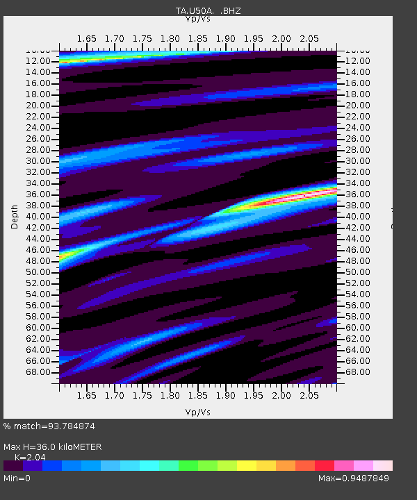
| Estimated Moho Depth: |
36.0 km |
| Estimated Crust Vp/Vs: |
2.04 |
| Assumed Crust Vp: |
6.476 km/s |
| Estimated Crust Vs: |
3.174 km/s |
| Estimated Crust Poisson's Ratio: |
0.34 |
|
| Radial Match: |
93.784874 % |
| Radial Bump: |
282 |
| Transverse Match: |
75.30651 % |
| Transverse Bump: |
400 |
| SOD ConfigId: |
478790 |
| Insert Time: |
2013-03-01 08:51:21.010 +0000 |
| GWidth: |
2.5 |
| Max Bumps: |
400 |
| Tol: |
0.001 |
|
Signal To Noise
| Channel | StoN | STA | LTA |
| TA:U50A: :BHZ:20121028T03:10:44.200005Z | 2.5186398 | 3.3030615E-6 | 1.3114466E-6 |
| TA:U50A: :BHN:20121028T03:10:44.200005Z | 2.7063837 | 2.2489335E-6 | 8.309736E-7 |
| TA:U50A: :BHE:20121028T03:10:44.200005Z | 2.0055525 | 1.4948931E-6 | 7.453772E-7 |
| Arrivals |
| Ps | 6.2 SECOND |
| PpPs | 16 SECOND |
| PsPs/PpSs | 22 SECOND |


