You are here: Home > Network List > TA - USArray Transportable Network (new EarthScope stations) Stations List
> Station R49A Shelbyville, KY, USA > Earthquake Result Viewer
R49A Shelbyville, KY, USA - Earthquake Result Viewer
| Earthquake location: |
Queen Charlotte Islands Region |
| Earthquake latitude/longitude: |
52.8/-132.1 |
| Earthquake time(UTC): |
2012/10/28 (302) 03:04:08 GMT |
| Earthquake Depth: |
14 km |
| Earthquake Magnitude: |
6.5 MB, 7.5 MS, 7.8 MW, 7.8 MW |
| Earthquake Catalog/Contributor: |
WHDF/NEIC |
|
| Network: |
TA USArray Transportable Network (new EarthScope stations) |
| Station: |
R49A Shelbyville, KY, USA |
| Lat/Lon: |
38.29 N/85.17 W |
| Elevation: |
251 m |
|
| Distance: |
35.3 deg |
| Az: |
95.18 deg |
| Baz: |
309.765 deg |
| Ray Param: |
0.077310875 |
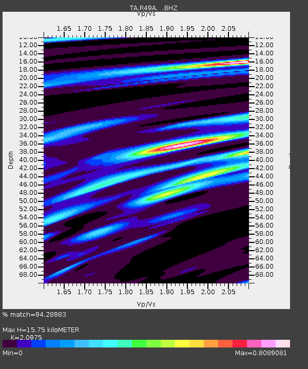
| Estimated Moho Depth: |
15.75 km |
| Estimated Crust Vp/Vs: |
2.10 |
| Assumed Crust Vp: |
6.498 km/s |
| Estimated Crust Vs: |
3.098 km/s |
| Estimated Crust Poisson's Ratio: |
0.35 |
|
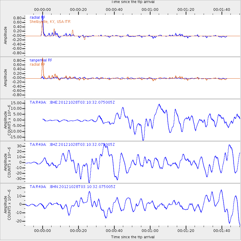
| Radial Match: |
94.28983 % |
| Radial Bump: |
207 |
| Transverse Match: |
65.81103 % |
| Transverse Bump: |
400 |
| SOD ConfigId: |
478790 |
| Insert Time: |
2013-03-01 08:51:52.501 +0000 |
| GWidth: |
2.5 |
| Max Bumps: |
400 |
| Tol: |
0.001 |
|
Signal To Noise
| Channel | StoN | STA | LTA |
| TA:R49A: :BHZ:20121028T03:10:32.075005Z | 6.457815 | 4.741588E-6 | 7.3424025E-7 |
| TA:R49A: :BHN:20121028T03:10:32.075005Z | 3.000867 | 2.2952863E-6 | 7.6487447E-7 |
| TA:R49A: :BHE:20121028T03:10:32.075005Z | 4.5248413 | 2.2059492E-6 | 4.875197E-7 |
| Arrivals |
| Ps | 2.8 SECOND |
| PpPs | 7.0 SECOND |
| PsPs/PpSs | 9.9 SECOND |


