You are here: Home > Network List > TA - USArray Transportable Network (new EarthScope stations) Stations List
> Station O48A Farmland, IN, USA > Earthquake Result Viewer
O48A Farmland, IN, USA - Earthquake Result Viewer
| Earthquake location: |
Queen Charlotte Islands Region |
| Earthquake latitude/longitude: |
52.8/-132.1 |
| Earthquake time(UTC): |
2012/10/28 (302) 03:04:08 GMT |
| Earthquake Depth: |
14 km |
| Earthquake Magnitude: |
6.5 MB, 7.5 MS, 7.8 MW, 7.8 MW |
| Earthquake Catalog/Contributor: |
WHDF/NEIC |
|
| Network: |
TA USArray Transportable Network (new EarthScope stations) |
| Station: |
O48A Farmland, IN, USA |
| Lat/Lon: |
40.26 N/85.16 W |
| Elevation: |
300 m |
|
| Distance: |
34.0 deg |
| Az: |
92.47 deg |
| Baz: |
307.545 deg |
| Ray Param: |
0.07792354 |
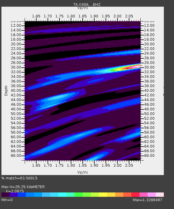
| Estimated Moho Depth: |
29.25 km |
| Estimated Crust Vp/Vs: |
2.10 |
| Assumed Crust Vp: |
6.498 km/s |
| Estimated Crust Vs: |
3.098 km/s |
| Estimated Crust Poisson's Ratio: |
0.35 |
|
| Radial Match: |
93.58815 % |
| Radial Bump: |
258 |
| Transverse Match: |
72.936584 % |
| Transverse Bump: |
400 |
| SOD ConfigId: |
478790 |
| Insert Time: |
2013-03-01 08:52:36.446 +0000 |
| GWidth: |
2.5 |
| Max Bumps: |
400 |
| Tol: |
0.001 |
|
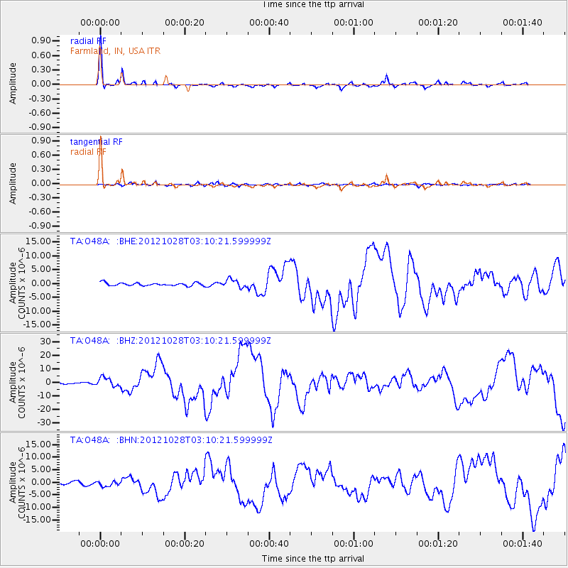
Signal To Noise
| Channel | StoN | STA | LTA |
| TA:O48A: :BHZ:20121028T03:10:21.599999Z | 6.0499444 | 3.3528113E-6 | 5.541888E-7 |
| TA:O48A: :BHN:20121028T03:10:21.599999Z | 1.4281622 | 9.764707E-7 | 6.8372526E-7 |
| TA:O48A: :BHE:20121028T03:10:21.599999Z | 2.8620727 | 1.5158906E-6 | 5.296478E-7 |
| Arrivals |
| Ps | 5.3 SECOND |
| PpPs | 13 SECOND |
| PsPs/PpSs | 18 SECOND |


