You are here: Home > Network List > TA - USArray Transportable Network (new EarthScope stations) Stations List
> Station M49A Liberty Center, OH, USA > Earthquake Result Viewer
M49A Liberty Center, OH, USA - Earthquake Result Viewer
| Earthquake location: |
Queen Charlotte Islands Region |
| Earthquake latitude/longitude: |
52.8/-132.1 |
| Earthquake time(UTC): |
2012/10/28 (302) 03:04:08 GMT |
| Earthquake Depth: |
14 km |
| Earthquake Magnitude: |
6.5 MB, 7.5 MS, 7.8 MW, 7.8 MW |
| Earthquake Catalog/Contributor: |
WHDF/NEIC |
|
| Network: |
TA USArray Transportable Network (new EarthScope stations) |
| Station: |
M49A Liberty Center, OH, USA |
| Lat/Lon: |
41.47 N/83.98 W |
| Elevation: |
203 m |
|
| Distance: |
34.0 deg |
| Az: |
89.772 deg |
| Baz: |
306.078 deg |
| Ray Param: |
0.077929124 |
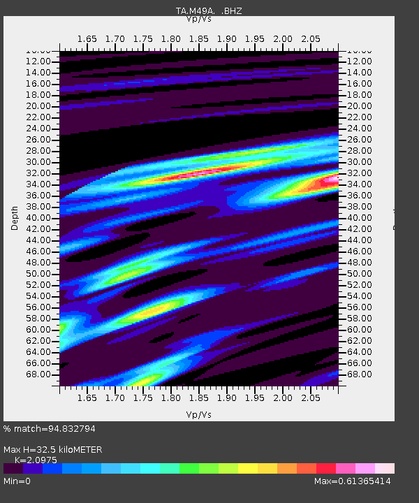
| Estimated Moho Depth: |
32.5 km |
| Estimated Crust Vp/Vs: |
2.10 |
| Assumed Crust Vp: |
6.498 km/s |
| Estimated Crust Vs: |
3.098 km/s |
| Estimated Crust Poisson's Ratio: |
0.35 |
|
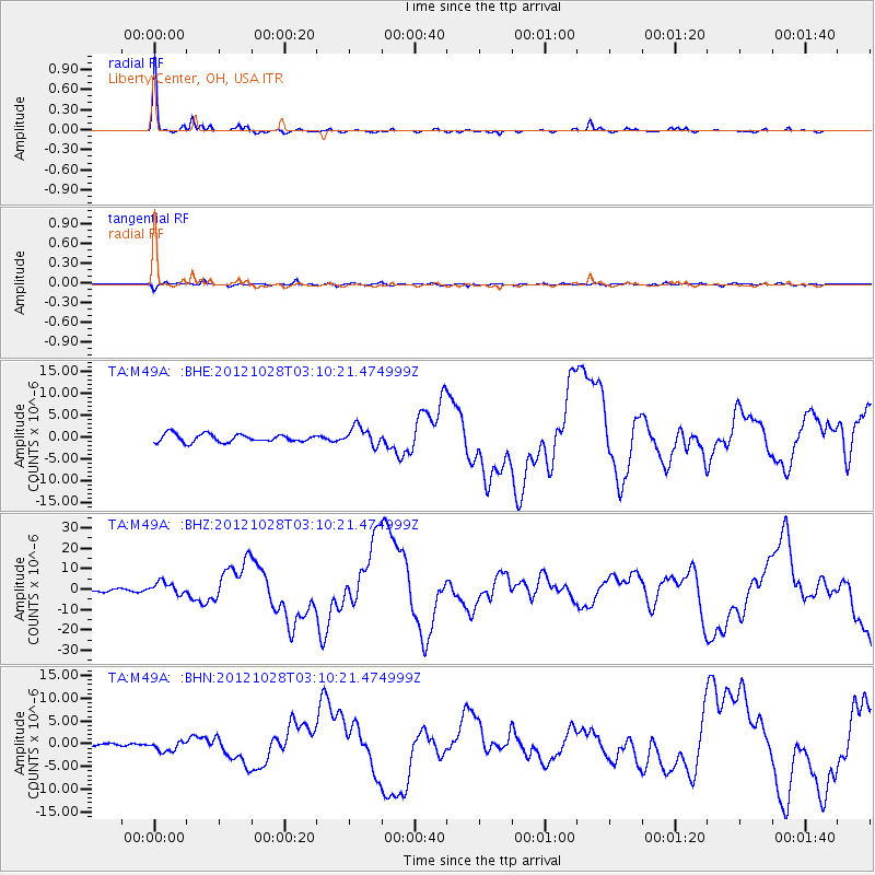
| Radial Match: |
94.832794 % |
| Radial Bump: |
195 |
| Transverse Match: |
73.60536 % |
| Transverse Bump: |
400 |
| SOD ConfigId: |
478790 |
| Insert Time: |
2013-03-01 08:53:08.031 +0000 |
| GWidth: |
2.5 |
| Max Bumps: |
400 |
| Tol: |
0.001 |
|
Signal To Noise
| Channel | StoN | STA | LTA |
| TA:M49A: :BHZ:20121028T03:10:21.474999Z | 3.6718333 | 2.988009E-6 | 8.137649E-7 |
| TA:M49A: :BHN:20121028T03:10:21.474999Z | 2.971713 | 1.1064201E-6 | 3.723173E-7 |
| TA:M49A: :BHE:20121028T03:10:21.474999Z | 2.3492444 | 2.118363E-6 | 9.01721E-7 |
| Arrivals |
| Ps | 5.9 SECOND |
| PpPs | 14 SECOND |
| PsPs/PpSs | 20 SECOND |


