You are here: Home > Network List > TA - USArray Transportable Network (new EarthScope stations) Stations List
> Station E53A Dumoine, Pontiac MRC, QC, CAN > Earthquake Result Viewer
E53A Dumoine, Pontiac MRC, QC, CAN - Earthquake Result Viewer
| Earthquake location: |
Queen Charlotte Islands Region |
| Earthquake latitude/longitude: |
52.8/-132.1 |
| Earthquake time(UTC): |
2012/10/28 (302) 03:04:08 GMT |
| Earthquake Depth: |
14 km |
| Earthquake Magnitude: |
6.5 MB, 7.5 MS, 7.8 MW, 7.8 MW |
| Earthquake Catalog/Contributor: |
WHDF/NEIC |
|
| Network: |
TA USArray Transportable Network (new EarthScope stations) |
| Station: |
E53A Dumoine, Pontiac MRC, QC, CAN |
| Lat/Lon: |
46.38 N/77.66 W |
| Elevation: |
355 m |
|
| Distance: |
35.1 deg |
| Az: |
78.13 deg |
| Baz: |
300.851 deg |
| Ray Param: |
0.07737243 |
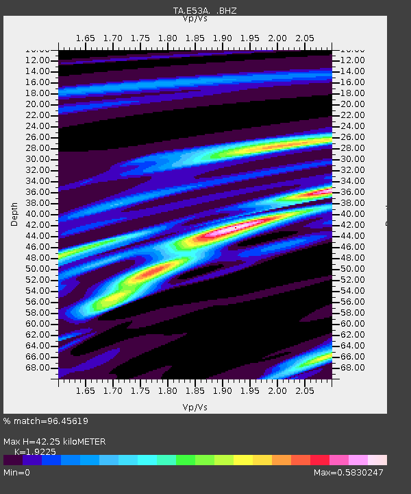
| Estimated Moho Depth: |
42.25 km |
| Estimated Crust Vp/Vs: |
1.92 |
| Assumed Crust Vp: |
6.622 km/s |
| Estimated Crust Vs: |
3.445 km/s |
| Estimated Crust Poisson's Ratio: |
0.31 |
|
| Radial Match: |
96.45619 % |
| Radial Bump: |
261 |
| Transverse Match: |
75.69169 % |
| Transverse Bump: |
400 |
| SOD ConfigId: |
478790 |
| Insert Time: |
2013-03-01 08:55:00.237 +0000 |
| GWidth: |
2.5 |
| Max Bumps: |
400 |
| Tol: |
0.001 |
|

Signal To Noise
| Channel | StoN | STA | LTA |
| TA:E53A: :BHZ:20121028T03:10:31.050011Z | 8.184379 | 3.6229296E-6 | 4.42664E-7 |
| TA:E53A: :BHN:20121028T03:10:31.050011Z | 3.463618 | 1.1810376E-6 | 3.409838E-7 |
| TA:E53A: :BHE:20121028T03:10:31.050011Z | 5.022062 | 2.4688175E-6 | 4.9159434E-7 |
| Arrivals |
| Ps | 6.3 SECOND |
| PpPs | 17 SECOND |
| PsPs/PpSs | 24 SECOND |


