You are here: Home > Network List > TA - USArray Transportable Network (new EarthScope stations) Stations List
> Station I49A Point Hope, MI, USA > Earthquake Result Viewer
I49A Point Hope, MI, USA - Earthquake Result Viewer
| Earthquake location: |
Queen Charlotte Islands Region |
| Earthquake latitude/longitude: |
52.8/-132.1 |
| Earthquake time(UTC): |
2012/10/28 (302) 03:04:08 GMT |
| Earthquake Depth: |
14 km |
| Earthquake Magnitude: |
6.5 MB, 7.5 MS, 7.8 MW, 7.8 MW |
| Earthquake Catalog/Contributor: |
WHDF/NEIC |
|
| Network: |
TA USArray Transportable Network (new EarthScope stations) |
| Station: |
I49A Point Hope, MI, USA |
| Lat/Lon: |
43.94 N/82.82 W |
| Elevation: |
217 m |
|
| Distance: |
33.3 deg |
| Az: |
85.244 deg |
| Baz: |
303.087 deg |
| Ray Param: |
0.07825175 |
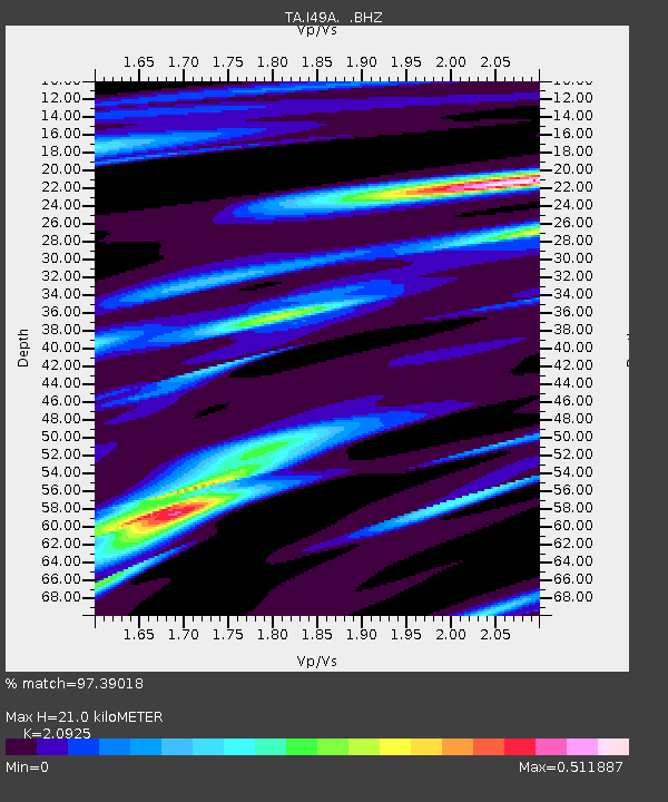
| Estimated Moho Depth: |
21.0 km |
| Estimated Crust Vp/Vs: |
2.09 |
| Assumed Crust Vp: |
6.483 km/s |
| Estimated Crust Vs: |
3.098 km/s |
| Estimated Crust Poisson's Ratio: |
0.35 |
|
| Radial Match: |
97.39018 % |
| Radial Bump: |
210 |
| Transverse Match: |
66.28084 % |
| Transverse Bump: |
400 |
| SOD ConfigId: |
478790 |
| Insert Time: |
2013-03-01 08:55:41.536 +0000 |
| GWidth: |
2.5 |
| Max Bumps: |
400 |
| Tol: |
0.001 |
|

Signal To Noise
| Channel | StoN | STA | LTA |
| TA:I49A: :BHZ:20121028T03:10:15.399987Z | 4.8506994 | 4.039145E-6 | 8.3269333E-7 |
| TA:I49A: :BHN:20121028T03:10:15.399987Z | 0.7435251 | 1.0695845E-6 | 1.4385317E-6 |
| TA:I49A: :BHE:20121028T03:10:15.399987Z | 2.4688754 | 2.4863743E-6 | 1.0070877E-6 |
| Arrivals |
| Ps | 3.8 SECOND |
| PpPs | 9.4 SECOND |
| PsPs/PpSs | 13 SECOND |


