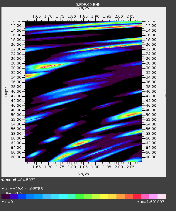
FDF Fort de France, Martinique France - Earthquake Result Viewer
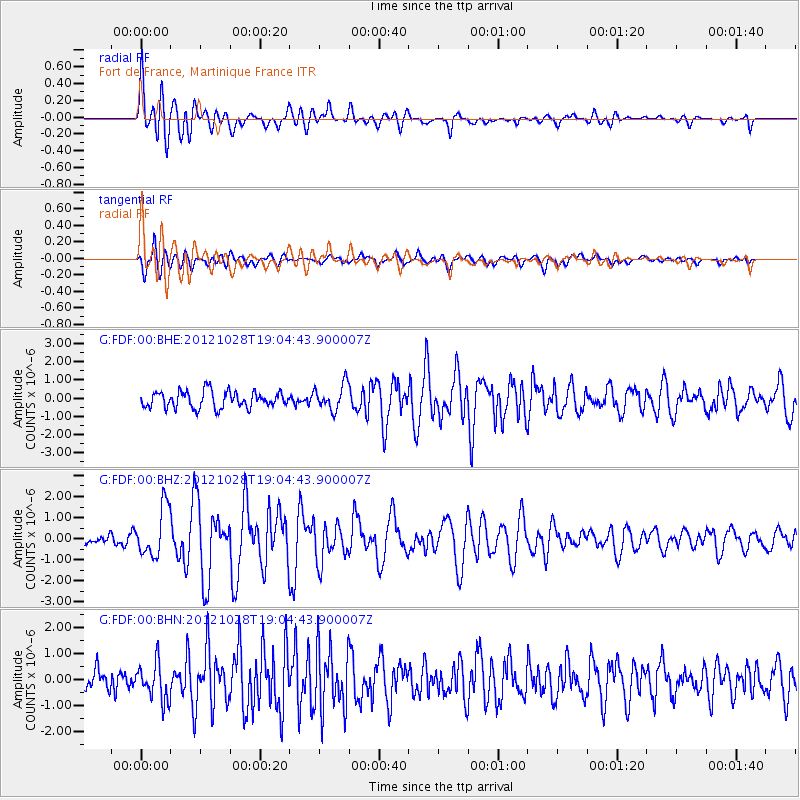
Earthquake location: Queen Charlotte Islands Region
Earthquake latitude/longitude: 52.7/-132.6
Earthquake time(UTC): 2012/10/28 (302) 18:54:20 GMT
Earthquake Depth: 9.0 km
Earthquake Magnitude: 5.9 MB, 6.2 MS, 6.3 MW, 6.3 MW
Earthquake Catalog/Contributor: WHDF/NEIC
Network: G GEOSCOPE
Station: FDF Fort de France, Martinique France
Lat/Lon: 14.73 N/61.14 W
Elevation: 467 m
Distance: 67.2 deg
Az: 95.612 deg
Baz: 321.219 deg
Ray Param: 0.057126496
Estimated Moho Depth: 29.0 km
Estimated Crust Vp/Vs: 1.71
Assumed Crust Vp: 5.88 km/s
Estimated Crust Vs: 3.449 km/s
Estimated Crust Poisson's Ratio: 0.24
Radial Match: 84.5977 %
Radial Bump: 400
Transverse Match: 70.46813 %
Transverse Bump: 400
SOD ConfigId: 478790
Insert Time: 2013-03-01 09:01:21.956 +0000
GWidth: 2.5
Max Bumps: 400
Tol: 0.001

Signal To Noise

ChannelStoNSTALTA
G:FDF:00:BHZ:20121028T19:04:43.900007Z5.47730161.1746886E-62.1446483E-7
G:FDF:00:BHN:20121028T19:04:43.900007Z1.87155787.17872E-73.8356922E-7
G:FDF:00:BHE:20121028T19:04:43.900007Z1.57993967.0767146E-74.4791045E-7
Arrivals
Ps3.6 SECOND
PpPs13 SECOND
PsPs/PpSs16 SECOND