You are here: Home > Network List > NE - New England Seismic Network Stations List
> Station PQI Presque Isle, ME, USA > Earthquake Result Viewer
PQI Presque Isle, ME, USA - Earthquake Result Viewer
*The percent match for this event was below the threshold and hence no stack was calculated.
| Earthquake location: |
Queen Charlotte Islands Region |
| Earthquake latitude/longitude: |
52.7/-132.6 |
| Earthquake time(UTC): |
2012/10/28 (302) 18:54:20 GMT |
| Earthquake Depth: |
9.0 km |
| Earthquake Magnitude: |
5.9 MB, 6.2 MS, 6.3 MW, 6.3 MW |
| Earthquake Catalog/Contributor: |
WHDF/NEIC |
|
| Network: |
NE New England Seismic Network |
| Station: |
PQI Presque Isle, ME, USA |
| Lat/Lon: |
46.67 N/68.02 W |
| Elevation: |
162 m |
|
| Distance: |
41.0 deg |
| Az: |
71.583 deg |
| Baz: |
302.967 deg |
| Ray Param: |
$rayparam |
*The percent match for this event was below the threshold and hence was not used in the summary stack. |
|
| Radial Match: |
76.45799 % |
| Radial Bump: |
361 |
| Transverse Match: |
53.458763 % |
| Transverse Bump: |
321 |
| SOD ConfigId: |
478790 |
| Insert Time: |
2013-03-01 09:08:27.470 +0000 |
| GWidth: |
2.5 |
| Max Bumps: |
400 |
| Tol: |
0.001 |
|
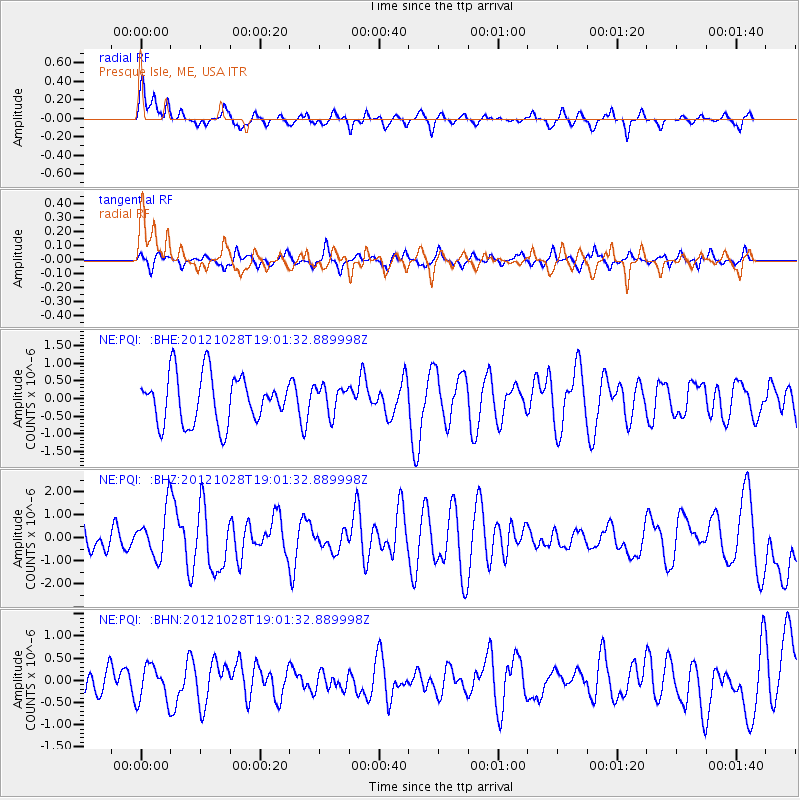
Signal To Noise
| Channel | StoN | STA | LTA |
| NE:PQI: :BHZ:20121028T19:01:32.889998Z | 1.7082179 | 1.0066517E-6 | 5.892993E-7 |
| NE:PQI: :BHN:20121028T19:01:32.889998Z | 1.5493985 | 4.0693388E-7 | 2.626399E-7 |
| NE:PQI: :BHE:20121028T19:01:32.889998Z | 0.58350706 | 3.9749258E-7 | 6.81213E-7 |
| Arrivals |
| Ps | |
| PpPs | |
| PsPs/PpSs | |


