You are here: Home > Network List > TA - USArray Transportable Network (new EarthScope stations) Stations List
> Station W44A Shelby Farms Park, Memphis, TN, USA > Earthquake Result Viewer
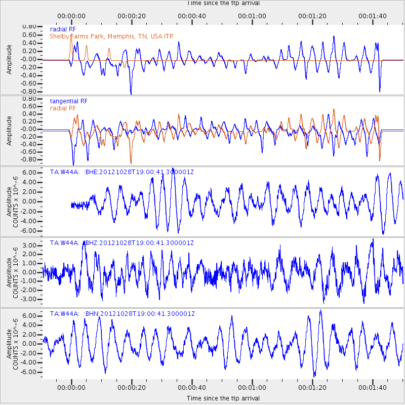
W44A Shelby Farms Park, Memphis, TN, USA - Earthquake Result Viewer
*The percent match for this event was below the threshold and hence no stack was calculated.
| Earthquake location: |
Queen Charlotte Islands Region |
| Earthquake latitude/longitude: |
52.7/-132.6 |
| Earthquake time(UTC): |
2012/10/28 (302) 18:54:20 GMT |
| Earthquake Depth: |
9.0 km |
| Earthquake Magnitude: |
5.9 MB, 6.2 MS, 6.3 MW, 6.3 MW |
| Earthquake Catalog/Contributor: |
WHDF/NEIC |
|
| Network: |
TA USArray Transportable Network (new EarthScope stations) |
| Station: |
W44A Shelby Farms Park, Memphis, TN, USA |
| Lat/Lon: |
35.14 N/89.82 W |
| Elevation: |
101 m |
|
| Distance: |
34.8 deg |
| Az: |
102.969 deg |
| Baz: |
313.612 deg |
| Ray Param: |
$rayparam |
*The percent match for this event was below the threshold and hence was not used in the summary stack. |
|
| Radial Match: |
50.272655 % |
| Radial Bump: |
400 |
| Transverse Match: |
66.524864 % |
| Transverse Bump: |
326 |
| SOD ConfigId: |
478790 |
| Insert Time: |
2013-03-01 09:13:52.246 +0000 |
| GWidth: |
2.5 |
| Max Bumps: |
400 |
| Tol: |
0.001 |
|
Signal To Noise
| Channel | StoN | STA | LTA |
| TA:W44A: :BHZ:20121028T19:00:41.300001Z | 2.7337725 | 1.7441105E-6 | 6.3798666E-7 |
| TA:W44A: :BHN:20121028T19:00:41.300001Z | 1.2952287 | 3.3493218E-6 | 2.585892E-6 |
| TA:W44A: :BHE:20121028T19:00:41.300001Z | 2.6292968 | 4.1843878E-6 | 1.5914475E-6 |
| Arrivals |
| Ps | |
| PpPs | |
| PsPs/PpSs | |


