You are here: Home > Network List > G - GEOSCOPE Stations List
> Station WUS Wushi, Xinjiang Uygur, China > Earthquake Result Viewer
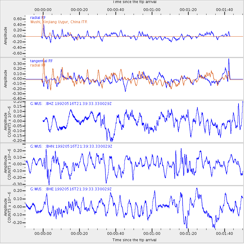
WUS Wushi, Xinjiang Uygur, China - Earthquake Result Viewer
*The percent match for this event was below the threshold and hence no stack was calculated.
| Earthquake location: |
Sunda Strait, Indonesia |
| Earthquake latitude/longitude: |
-6.0/105.3 |
| Earthquake time(UTC): |
1992/05/16 (137) 21:30:52 GMT |
| Earthquake Depth: |
33 km |
| Earthquake Magnitude: |
5.7 MS, 5.3 MB |
| Earthquake Catalog/Contributor: |
WHDF/NEIC |
|
| Network: |
G GEOSCOPE |
| Station: |
WUS Wushi, Xinjiang Uygur, China |
| Lat/Lon: |
41.20 N/79.22 E |
| Elevation: |
1457 m |
|
| Distance: |
52.7 deg |
| Az: |
335.322 deg |
| Baz: |
146.615 deg |
| Ray Param: |
$rayparam |
*The percent match for this event was below the threshold and hence was not used in the summary stack. |
|
| Radial Match: |
56.093933 % |
| Radial Bump: |
400 |
| Transverse Match: |
55.218018 % |
| Transverse Bump: |
400 |
| SOD ConfigId: |
4480 |
| Insert Time: |
2010-02-27 01:09:18.901 +0000 |
| GWidth: |
2.5 |
| Max Bumps: |
400 |
| Tol: |
0.001 |
|
Signal To Noise
| Channel | StoN | STA | LTA |
| G:WUS: :BHN:19920516T21:39:33.330029Z | 2.7215743 | 1.2865105E-7 | 4.7270817E-8 |
| G:WUS: :BHE:19920516T21:39:33.330029Z | 1.7316877 | 8.104538E-8 | 4.6801382E-8 |
| G:WUS: :BHZ:19920516T21:39:33.330029Z | 1.0303332 | 5.4483273E-8 | 5.287928E-8 |
| Arrivals |
| Ps | |
| PpPs | |
| PsPs/PpSs | |


