You are here: Home > Network List > TA - USArray Transportable Network (new EarthScope stations) Stations List
> Station N45A Kentland, IN, USA > Earthquake Result Viewer
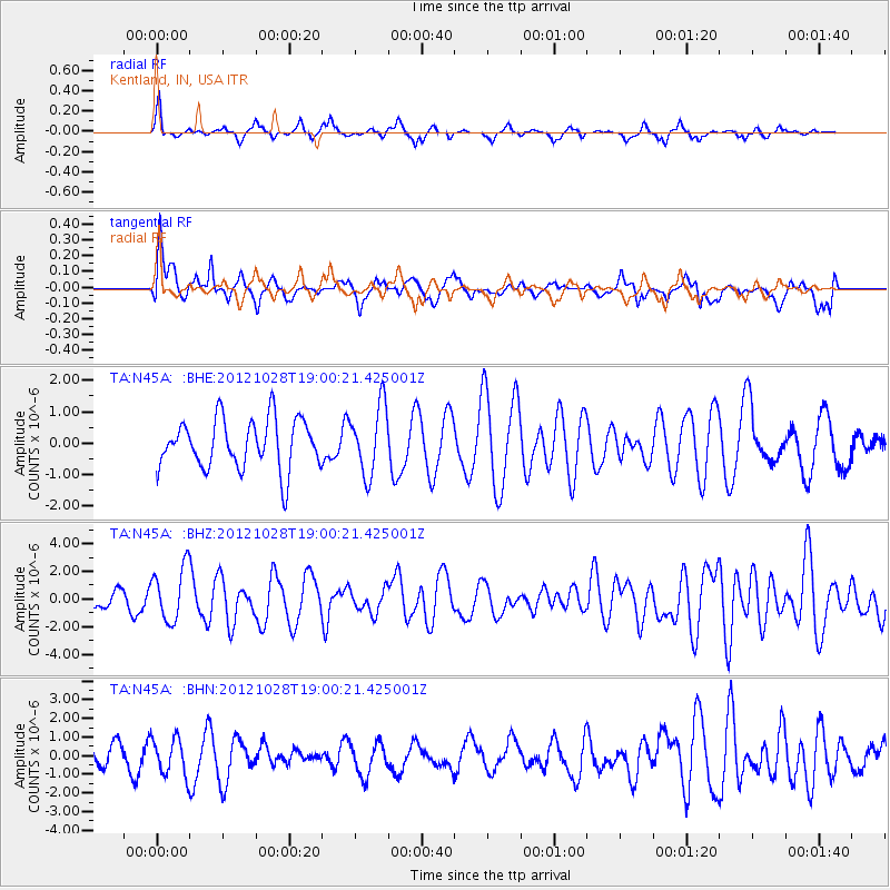
N45A Kentland, IN, USA - Earthquake Result Viewer
*The percent match for this event was below the threshold and hence no stack was calculated.
| Earthquake location: |
Queen Charlotte Islands Region |
| Earthquake latitude/longitude: |
52.7/-132.6 |
| Earthquake time(UTC): |
2012/10/28 (302) 18:54:20 GMT |
| Earthquake Depth: |
9.0 km |
| Earthquake Magnitude: |
5.9 MB, 6.2 MS, 6.3 MW, 6.3 MW |
| Earthquake Catalog/Contributor: |
WHDF/NEIC |
|
| Network: |
TA USArray Transportable Network (new EarthScope stations) |
| Station: |
N45A Kentland, IN, USA |
| Lat/Lon: |
40.85 N/87.51 W |
| Elevation: |
206 m |
|
| Distance: |
32.5 deg |
| Az: |
92.994 deg |
| Baz: |
306.719 deg |
| Ray Param: |
$rayparam |
*The percent match for this event was below the threshold and hence was not used in the summary stack. |
|
| Radial Match: |
67.02782 % |
| Radial Bump: |
327 |
| Transverse Match: |
66.075165 % |
| Transverse Bump: |
400 |
| SOD ConfigId: |
478790 |
| Insert Time: |
2013-03-01 09:16:03.753 +0000 |
| GWidth: |
2.5 |
| Max Bumps: |
400 |
| Tol: |
0.001 |
|
Signal To Noise
| Channel | StoN | STA | LTA |
| TA:N45A: :BHZ:20121028T19:00:21.425001Z | 3.5753446 | 1.9678307E-6 | 5.503891E-7 |
| TA:N45A: :BHN:20121028T19:00:21.425001Z | 2.136157 | 9.876547E-7 | 4.6235118E-7 |
| TA:N45A: :BHE:20121028T19:00:21.425001Z | 1.3791201 | 1.0847559E-6 | 7.8655654E-7 |
| Arrivals |
| Ps | |
| PpPs | |
| PsPs/PpSs | |


