You are here: Home > Network List > TA - USArray Transportable Network (new EarthScope stations) Stations List
> Station R45A Skylar, Fairfield, IL, USA > Earthquake Result Viewer
R45A Skylar, Fairfield, IL, USA - Earthquake Result Viewer

| Earthquake location: |
Queen Charlotte Islands Region |
| Earthquake latitude/longitude: |
52.7/-132.6 |
| Earthquake time(UTC): |
2012/10/28 (302) 18:54:20 GMT |
| Earthquake Depth: |
9.0 km |
| Earthquake Magnitude: |
5.9 MB, 6.2 MS, 6.3 MW, 6.3 MW |
| Earthquake Catalog/Contributor: |
WHDF/NEIC |
|
| Network: |
TA USArray Transportable Network (new EarthScope stations) |
| Station: |
R45A Skylar, Fairfield, IL, USA |
| Lat/Lon: |
38.29 N/88.28 W |
| Elevation: |
143 m |
|
| Distance: |
33.7 deg |
| Az: |
97.336 deg |
| Baz: |
309.869 deg |
| Ray Param: |
0.07810603 |
| Estimated Moho Depth: |
21.0 km |
| Estimated Crust Vp/Vs: |
1.80 |
| Assumed Crust Vp: |
6.444 km/s |
| Estimated Crust Vs: |
3.58 km/s |
| Estimated Crust Poisson's Ratio: |
0.28 |
|
| Radial Match: |
81.58916 % |
| Radial Bump: |
303 |
| Transverse Match: |
48.4076 % |
| Transverse Bump: |
353 |
| SOD ConfigId: |
478790 |
| Insert Time: |
2013-03-01 09:16:30.867 +0000 |
| GWidth: |
2.5 |
| Max Bumps: |
400 |
| Tol: |
0.001 |
|
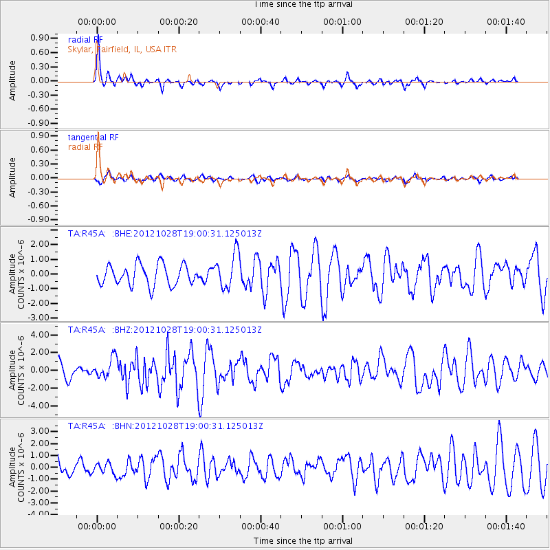
Signal To Noise
| Channel | StoN | STA | LTA |
| TA:R45A: :BHZ:20121028T19:00:31.125013Z | 1.5006347 | 1.1694397E-6 | 7.792967E-7 |
| TA:R45A: :BHN:20121028T19:00:31.125013Z | 0.5571266 | 4.5407668E-7 | 8.150332E-7 |
| TA:R45A: :BHE:20121028T19:00:31.125013Z | 1.7396642 | 1.2257386E-6 | 7.045835E-7 |
| Arrivals |
| Ps | 2.8 SECOND |
| PpPs | 8.4 SECOND |
| PsPs/PpSs | 11 SECOND |


