You are here: Home > Network List > TA - USArray Transportable Network (new EarthScope stations) Stations List
> Station X51A Calhoun, GA, USA > Earthquake Result Viewer
X51A Calhoun, GA, USA - Earthquake Result Viewer
| Earthquake location: |
Queen Charlotte Islands Region |
| Earthquake latitude/longitude: |
52.7/-132.6 |
| Earthquake time(UTC): |
2012/10/28 (302) 18:54:20 GMT |
| Earthquake Depth: |
9.0 km |
| Earthquake Magnitude: |
5.9 MB, 6.2 MS, 6.3 MW, 6.3 MW |
| Earthquake Catalog/Contributor: |
WHDF/NEIC |
|
| Network: |
TA USArray Transportable Network (new EarthScope stations) |
| Station: |
X51A Calhoun, GA, USA |
| Lat/Lon: |
34.57 N/84.86 W |
| Elevation: |
214 m |
|
| Distance: |
38.2 deg |
| Az: |
98.958 deg |
| Baz: |
313.209 deg |
| Ray Param: |
0.07570416 |
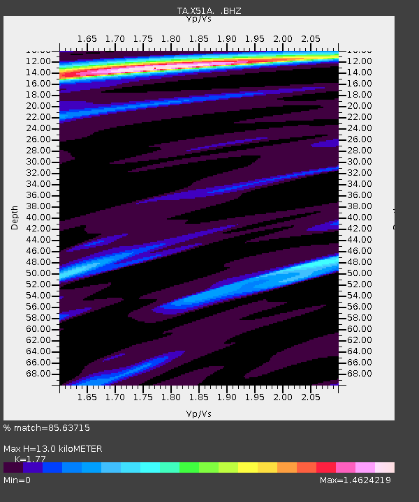
| Estimated Moho Depth: |
13.0 km |
| Estimated Crust Vp/Vs: |
1.77 |
| Assumed Crust Vp: |
6.35 km/s |
| Estimated Crust Vs: |
3.588 km/s |
| Estimated Crust Poisson's Ratio: |
0.27 |
|
| Radial Match: |
85.63715 % |
| Radial Bump: |
281 |
| Transverse Match: |
46.661716 % |
| Transverse Bump: |
309 |
| SOD ConfigId: |
478790 |
| Insert Time: |
2013-03-01 09:18:51.713 +0000 |
| GWidth: |
2.5 |
| Max Bumps: |
400 |
| Tol: |
0.001 |
|

Signal To Noise
| Channel | StoN | STA | LTA |
| TA:X51A: :BHZ:20121028T19:01:09.875013Z | 2.245624 | 2.6066657E-6 | 1.1607757E-6 |
| TA:X51A: :BHN:20121028T19:01:09.875013Z | 1.4403516 | 1.4679912E-6 | 1.0191895E-6 |
| TA:X51A: :BHE:20121028T19:01:09.875013Z | 1.9079126 | 1.7030517E-6 | 8.926257E-7 |
| Arrivals |
| Ps | 1.7 SECOND |
| PpPs | 5.3 SECOND |
| PsPs/PpSs | 7.0 SECOND |


