You are here: Home > Network List > TA - USArray Transportable Network (new EarthScope stations) Stations List
> Station Y53A Monroe, GA, USA > Earthquake Result Viewer
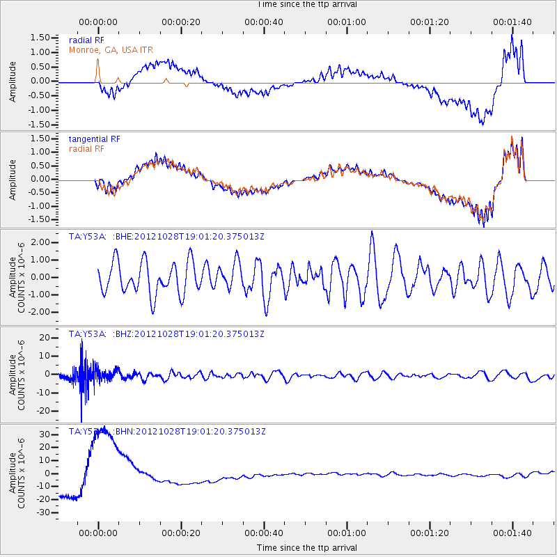
Y53A Monroe, GA, USA - Earthquake Result Viewer
*The percent match for this event was below the threshold and hence no stack was calculated.
| Earthquake location: |
Queen Charlotte Islands Region |
| Earthquake latitude/longitude: |
52.7/-132.6 |
| Earthquake time(UTC): |
2012/10/28 (302) 18:54:20 GMT |
| Earthquake Depth: |
9.0 km |
| Earthquake Magnitude: |
5.9 MB, 6.2 MS, 6.3 MW, 6.3 MW |
| Earthquake Catalog/Contributor: |
WHDF/NEIC |
|
| Network: |
TA USArray Transportable Network (new EarthScope stations) |
| Station: |
Y53A Monroe, GA, USA |
| Lat/Lon: |
33.86 N/83.58 W |
| Elevation: |
234 m |
|
| Distance: |
39.4 deg |
| Az: |
98.621 deg |
| Baz: |
313.659 deg |
| Ray Param: |
$rayparam |
*The percent match for this event was below the threshold and hence was not used in the summary stack. |
|
| Radial Match: |
46.79747 % |
| Radial Bump: |
400 |
| Transverse Match: |
49.122326 % |
| Transverse Bump: |
400 |
| SOD ConfigId: |
478790 |
| Insert Time: |
2013-03-01 09:19:14.617 +0000 |
| GWidth: |
2.5 |
| Max Bumps: |
400 |
| Tol: |
0.001 |
|
Signal To Noise
| Channel | StoN | STA | LTA |
| TA:Y53A: :BHZ:20121028T19:01:20.375013Z | 1.8241279 | 2.9998625E-6 | 1.6445462E-6 |
| TA:Y53A: :BHN:20121028T19:01:20.375013Z | 6.8624916 | 3.801824E-5 | 5.540005E-6 |
| TA:Y53A: :BHE:20121028T19:01:20.375013Z | 0.8559671 | 7.671435E-7 | 8.962301E-7 |
| Arrivals |
| Ps | |
| PpPs | |
| PsPs/PpSs | |


