You are here: Home > Network List > TA - USArray Transportable Network (new EarthScope stations) Stations List
> Station Q49A Aurora, IN, USA > Earthquake Result Viewer
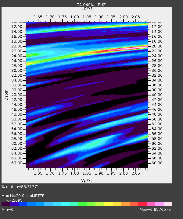
Q49A Aurora, IN, USA - Earthquake Result Viewer
| Earthquake location: |
Queen Charlotte Islands Region |
| Earthquake latitude/longitude: |
52.7/-132.6 |
| Earthquake time(UTC): |
2012/10/28 (302) 18:54:20 GMT |
| Earthquake Depth: |
9.0 km |
| Earthquake Magnitude: |
5.9 MB, 6.2 MS, 6.3 MW, 6.3 MW |
| Earthquake Catalog/Contributor: |
WHDF/NEIC |
|
| Network: |
TA USArray Transportable Network (new EarthScope stations) |
| Station: |
Q49A Aurora, IN, USA |
| Lat/Lon: |
39.01 N/84.90 W |
| Elevation: |
264 m |
|
| Distance: |
35.3 deg |
| Az: |
93.397 deg |
| Baz: |
308.726 deg |
| Ray Param: |
0.07731644 |
| Estimated Moho Depth: |
20.0 km |
| Estimated Crust Vp/Vs: |
2.10 |
| Assumed Crust Vp: |
6.498 km/s |
| Estimated Crust Vs: |
3.101 km/s |
| Estimated Crust Poisson's Ratio: |
0.35 |
|
| Radial Match: |
83.71771 % |
| Radial Bump: |
346 |
| Transverse Match: |
55.662067 % |
| Transverse Bump: |
400 |
| SOD ConfigId: |
478790 |
| Insert Time: |
2013-03-01 09:20:38.785 +0000 |
| GWidth: |
2.5 |
| Max Bumps: |
400 |
| Tol: |
0.001 |
|

Signal To Noise
| Channel | StoN | STA | LTA |
| TA:Q49A: :BHZ:20121028T19:00:44.949995Z | 1.5289984 | 2.0454397E-6 | 1.3377645E-6 |
| TA:Q49A: :BHN:20121028T19:00:44.949995Z | 2.4875834 | 8.0270786E-7 | 3.226858E-7 |
| TA:Q49A: :BHE:20121028T19:00:44.949995Z | 1.0597371 | 9.609934E-7 | 9.068224E-7 |
| Arrivals |
| Ps | 3.6 SECOND |
| PpPs | 8.9 SECOND |
| PsPs/PpSs | 13 SECOND |


