You are here: Home > Network List > TA - USArray Transportable Network (new EarthScope stations) Stations List
> Station M50A Fremont, OH, USA > Earthquake Result Viewer
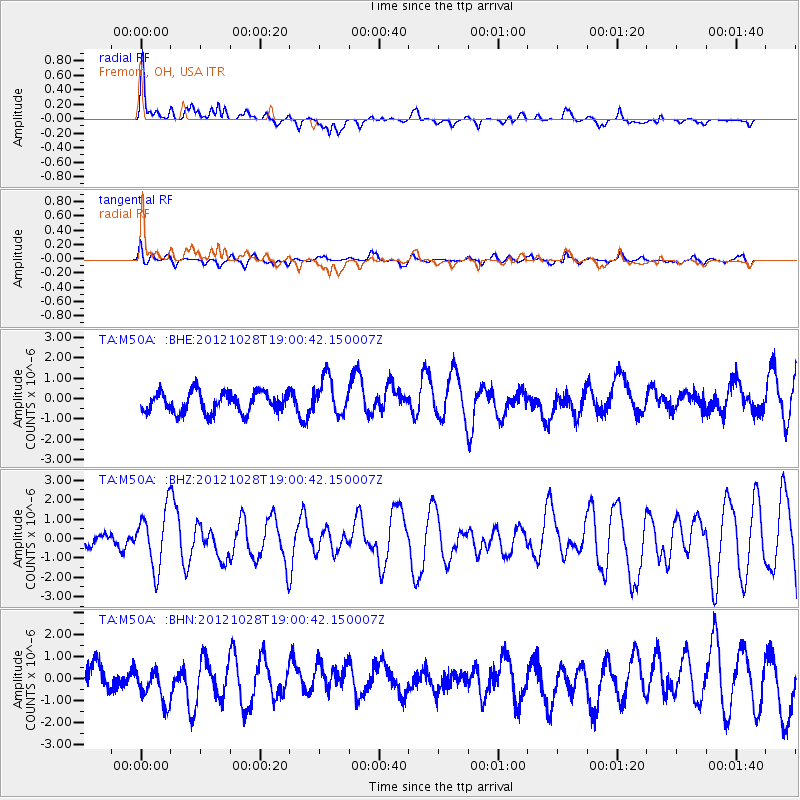
M50A Fremont, OH, USA - Earthquake Result Viewer
*The percent match for this event was below the threshold and hence no stack was calculated.
| Earthquake location: |
Queen Charlotte Islands Region |
| Earthquake latitude/longitude: |
52.7/-132.6 |
| Earthquake time(UTC): |
2012/10/28 (302) 18:54:20 GMT |
| Earthquake Depth: |
9.0 km |
| Earthquake Magnitude: |
5.9 MB, 6.2 MS, 6.3 MW, 6.3 MW |
| Earthquake Catalog/Contributor: |
WHDF/NEIC |
|
| Network: |
TA USArray Transportable Network (new EarthScope stations) |
| Station: |
M50A Fremont, OH, USA |
| Lat/Lon: |
41.40 N/83.04 W |
| Elevation: |
176 m |
|
| Distance: |
34.9 deg |
| Az: |
88.587 deg |
| Baz: |
305.982 deg |
| Ray Param: |
$rayparam |
*The percent match for this event was below the threshold and hence was not used in the summary stack. |
|
| Radial Match: |
74.342255 % |
| Radial Bump: |
400 |
| Transverse Match: |
50.96521 % |
| Transverse Bump: |
400 |
| SOD ConfigId: |
478790 |
| Insert Time: |
2013-03-01 09:21:07.521 +0000 |
| GWidth: |
2.5 |
| Max Bumps: |
400 |
| Tol: |
0.001 |
|
Signal To Noise
| Channel | StoN | STA | LTA |
| TA:M50A: :BHZ:20121028T19:00:42.150007Z | 2.2013006 | 1.4878394E-6 | 6.758911E-7 |
| TA:M50A: :BHN:20121028T19:00:42.150007Z | 1.3180671 | 8.331817E-7 | 6.321239E-7 |
| TA:M50A: :BHE:20121028T19:00:42.150007Z | 1.8416681 | 9.082566E-7 | 4.931706E-7 |
| Arrivals |
| Ps | |
| PpPs | |
| PsPs/PpSs | |


