You are here: Home > Network List > TA - USArray Transportable Network (new EarthScope stations) Stations List
> Station K47A Vremontville, MI, USA > Earthquake Result Viewer
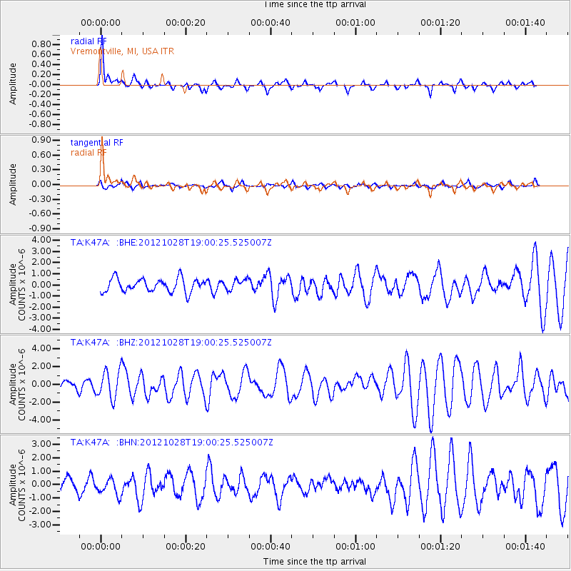
K47A Vremontville, MI, USA - Earthquake Result Viewer
*The percent match for this event was below the threshold and hence no stack was calculated.
| Earthquake location: |
Queen Charlotte Islands Region |
| Earthquake latitude/longitude: |
52.7/-132.6 |
| Earthquake time(UTC): |
2012/10/28 (302) 18:54:20 GMT |
| Earthquake Depth: |
9.0 km |
| Earthquake Magnitude: |
5.9 MB, 6.2 MS, 6.3 MW, 6.3 MW |
| Earthquake Catalog/Contributor: |
WHDF/NEIC |
|
| Network: |
TA USArray Transportable Network (new EarthScope stations) |
| Station: |
K47A Vremontville, MI, USA |
| Lat/Lon: |
42.67 N/85.00 W |
| Elevation: |
275 m |
|
| Distance: |
33.0 deg |
| Az: |
88.239 deg |
| Baz: |
304.387 deg |
| Ray Param: |
$rayparam |
*The percent match for this event was below the threshold and hence was not used in the summary stack. |
|
| Radial Match: |
72.16716 % |
| Radial Bump: |
322 |
| Transverse Match: |
50.834034 % |
| Transverse Bump: |
400 |
| SOD ConfigId: |
478790 |
| Insert Time: |
2013-03-01 09:21:47.746 +0000 |
| GWidth: |
2.5 |
| Max Bumps: |
400 |
| Tol: |
0.001 |
|
Signal To Noise
| Channel | StoN | STA | LTA |
| TA:K47A: :BHZ:20121028T19:00:25.525007Z | 2.8695142 | 1.5932501E-6 | 5.552334E-7 |
| TA:K47A: :BHN:20121028T19:00:25.525007Z | 0.95911914 | 6.2225695E-7 | 6.4877963E-7 |
| TA:K47A: :BHE:20121028T19:00:25.525007Z | 0.78798795 | 4.7174055E-7 | 5.9866466E-7 |
| Arrivals |
| Ps | |
| PpPs | |
| PsPs/PpSs | |


