You are here: Home > Network List > TA - USArray Transportable Network (new EarthScope stations) Stations List
> Station T56A Rocky Mt, VA, USA > Earthquake Result Viewer
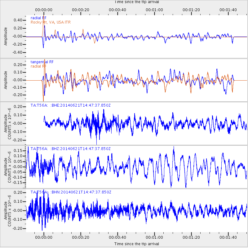
T56A Rocky Mt, VA, USA - Earthquake Result Viewer
*The percent match for this event was below the threshold and hence no stack was calculated.
| Earthquake location: |
Laptev Sea |
| Earthquake latitude/longitude: |
74.8/134.0 |
| Earthquake time(UTC): |
2014/06/21 (172) 14:37:21 GMT |
| Earthquake Depth: |
10 km |
| Earthquake Magnitude: |
3.6 mb |
| Earthquake Catalog/Contributor: |
ISC/ISC |
|
| Network: |
TA USArray Transportable Network (new EarthScope stations) |
| Station: |
T56A Rocky Mt, VA, USA |
| Lat/Lon: |
37.03 N/80.03 W |
| Elevation: |
387 m |
|
| Distance: |
66.2 deg |
| Az: |
29.333 deg |
| Baz: |
350.723 deg |
| Ray Param: |
$rayparam |
*The percent match for this event was below the threshold and hence was not used in the summary stack. |
|
| Radial Match: |
45.96678 % |
| Radial Bump: |
400 |
| Transverse Match: |
48.051804 % |
| Transverse Bump: |
400 |
| SOD ConfigId: |
3390531 |
| Insert Time: |
2019-04-12 09:23:55.002 +0000 |
| GWidth: |
2.5 |
| Max Bumps: |
400 |
| Tol: |
0.001 |
|
Signal To Noise
| Channel | StoN | STA | LTA |
| TA:T56A: :BHZ:20140621T14:47:37.850Z | 0.69840086 | 4.520301E-8 | 6.472359E-8 |
| TA:T56A: :BHN:20140621T14:47:37.850Z | 1.7310917 | 8.9661775E-8 | 5.179493E-8 |
| TA:T56A: :BHE:20140621T14:47:37.850Z | 1.7128147 | 7.173192E-8 | 4.187956E-8 |
| Arrivals |
| Ps | |
| PpPs | |
| PsPs/PpSs | |


