You are here: Home > Network List > TA - USArray Transportable Network (new EarthScope stations) Stations List
> Station Z42A Norrel Spur, Hamburg, AR, USA > Earthquake Result Viewer
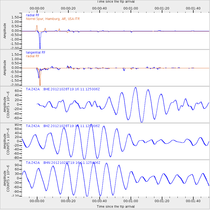
Z42A Norrel Spur, Hamburg, AR, USA - Earthquake Result Viewer
*The percent match for this event was below the threshold and hence no stack was calculated.
| Earthquake location: |
Queen Charlotte Islands Region |
| Earthquake latitude/longitude: |
52.3/-132.1 |
| Earthquake time(UTC): |
2012/10/28 (302) 19:09:53 GMT |
| Earthquake Depth: |
10 km |
| Earthquake Magnitude: |
5.6 MB, 5.8 MW, 5.5 MW |
| Earthquake Catalog/Contributor: |
WHDF/NEIC |
|
| Network: |
TA USArray Transportable Network (new EarthScope stations) |
| Station: |
Z42A Norrel Spur, Hamburg, AR, USA |
| Lat/Lon: |
33.27 N/91.95 W |
| Elevation: |
39 m |
|
| Distance: |
34.5 deg |
| Az: |
107.481 deg |
| Baz: |
315.631 deg |
| Ray Param: |
$rayparam |
*The percent match for this event was below the threshold and hence was not used in the summary stack. |
|
| Radial Match: |
98.58473 % |
| Radial Bump: |
122 |
| Transverse Match: |
81.155106 % |
| Transverse Bump: |
400 |
| SOD ConfigId: |
478790 |
| Insert Time: |
2013-03-01 09:38:52.782 +0000 |
| GWidth: |
2.5 |
| Max Bumps: |
400 |
| Tol: |
0.001 |
|
Signal To Noise
| Channel | StoN | STA | LTA |
| TA:Z42A: :BHZ:20121028T19:16:11.125006Z | 2.1021805 | 2.4878253E-5 | 1.18345E-5 |
| TA:Z42A: :BHN:20121028T19:16:11.125006Z | 2.3137867 | 4.281891E-5 | 1.8505989E-5 |
| TA:Z42A: :BHE:20121028T19:16:11.125006Z | 0.8947098 | 1.1419817E-5 | 1.2763711E-5 |
| Arrivals |
| Ps | |
| PpPs | |
| PsPs/PpSs | |


