You are here: Home > Network List > TA - USArray Transportable Network (new EarthScope stations) Stations List
> Station R42A Luebbering, MO, USA > Earthquake Result Viewer
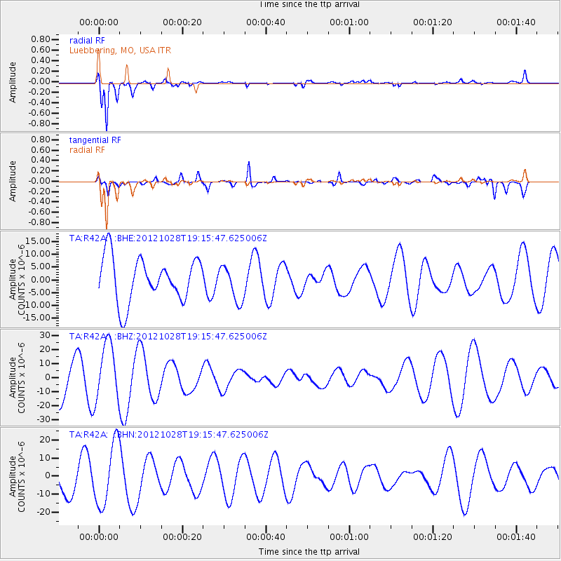
R42A Luebbering, MO, USA - Earthquake Result Viewer
*The percent match for this event was below the threshold and hence no stack was calculated.
| Earthquake location: |
Queen Charlotte Islands Region |
| Earthquake latitude/longitude: |
52.3/-132.1 |
| Earthquake time(UTC): |
2012/10/28 (302) 19:09:53 GMT |
| Earthquake Depth: |
10 km |
| Earthquake Magnitude: |
5.6 MB, 5.8 MW, 5.5 MW |
| Earthquake Catalog/Contributor: |
WHDF/NEIC |
|
| Network: |
TA USArray Transportable Network (new EarthScope stations) |
| Station: |
R42A Luebbering, MO, USA |
| Lat/Lon: |
38.28 N/90.79 W |
| Elevation: |
218 m |
|
| Distance: |
31.8 deg |
| Az: |
99.593 deg |
| Baz: |
309.692 deg |
| Ray Param: |
$rayparam |
*The percent match for this event was below the threshold and hence was not used in the summary stack. |
|
| Radial Match: |
92.00224 % |
| Radial Bump: |
359 |
| Transverse Match: |
67.92124 % |
| Transverse Bump: |
400 |
| SOD ConfigId: |
478790 |
| Insert Time: |
2013-03-01 09:39:59.928 +0000 |
| GWidth: |
2.5 |
| Max Bumps: |
400 |
| Tol: |
0.001 |
|
Signal To Noise
| Channel | StoN | STA | LTA |
| TA:R42A: :BHZ:20121028T19:15:47.625006Z | 2.0166836 | 2.0222049E-5 | 1.0027378E-5 |
| TA:R42A: :BHN:20121028T19:15:47.625006Z | 1.6492456 | 1.7808896E-5 | 1.0798206E-5 |
| TA:R42A: :BHE:20121028T19:15:47.625006Z | 0.82891744 | 7.145407E-6 | 8.620167E-6 |
| Arrivals |
| Ps | |
| PpPs | |
| PsPs/PpSs | |


