You are here: Home > Network List > TA - USArray Transportable Network (new EarthScope stations) Stations List
> Station 254A Abbeville, GA, USA > Earthquake Result Viewer
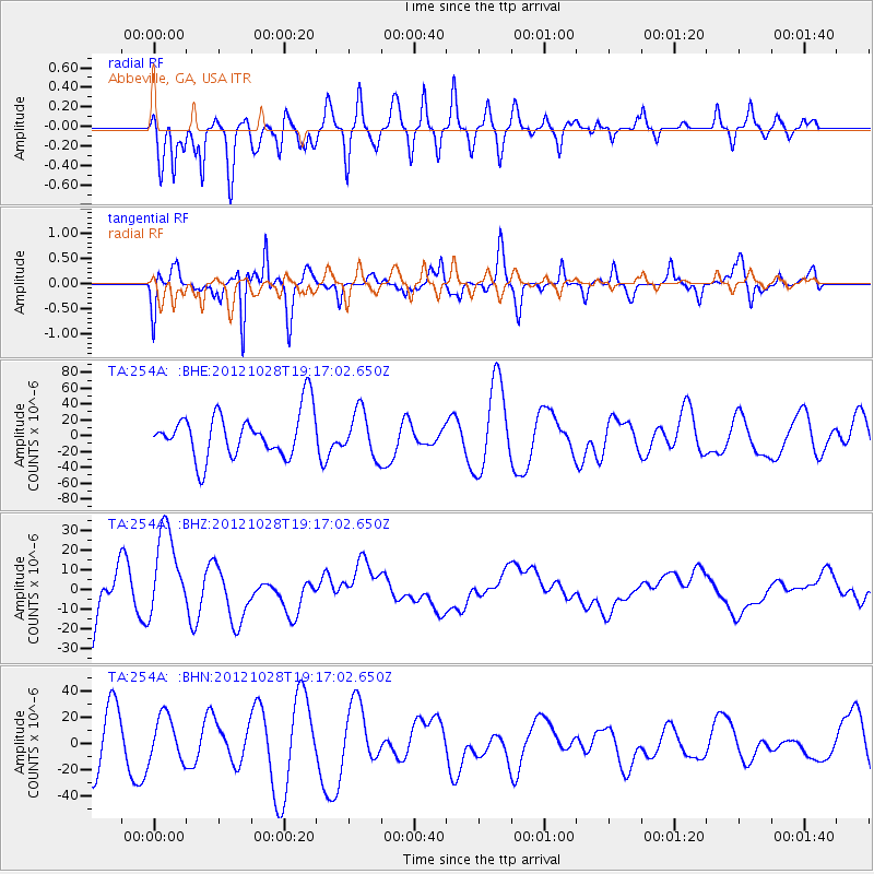
254A Abbeville, GA, USA - Earthquake Result Viewer
*The percent match for this event was below the threshold and hence no stack was calculated.
| Earthquake location: |
Queen Charlotte Islands Region |
| Earthquake latitude/longitude: |
52.3/-132.1 |
| Earthquake time(UTC): |
2012/10/28 (302) 19:09:53 GMT |
| Earthquake Depth: |
10 km |
| Earthquake Magnitude: |
5.6 MB, 5.8 MW, 5.5 MW |
| Earthquake Catalog/Contributor: |
WHDF/NEIC |
|
| Network: |
TA USArray Transportable Network (new EarthScope stations) |
| Station: |
254A Abbeville, GA, USA |
| Lat/Lon: |
31.95 N/83.29 W |
| Elevation: |
78 m |
|
| Distance: |
40.6 deg |
| Az: |
100.504 deg |
| Baz: |
314.737 deg |
| Ray Param: |
$rayparam |
*The percent match for this event was below the threshold and hence was not used in the summary stack. |
|
| Radial Match: |
69.5288 % |
| Radial Bump: |
400 |
| Transverse Match: |
53.890656 % |
| Transverse Bump: |
284 |
| SOD ConfigId: |
478790 |
| Insert Time: |
2013-03-01 09:44:26.254 +0000 |
| GWidth: |
2.5 |
| Max Bumps: |
400 |
| Tol: |
0.001 |
|
Signal To Noise
| Channel | StoN | STA | LTA |
| TA:254A: :BHZ:20121028T19:17:02.650Z | 2.2360334 | 2.265082E-5 | 1.0129911E-5 |
| TA:254A: :BHN:20121028T19:17:02.650Z | 0.9432734 | 1.6998421E-5 | 1.8020673E-5 |
| TA:254A: :BHE:20121028T19:17:02.650Z | 0.9954394 | 2.8192208E-5 | 2.832137E-5 |
| Arrivals |
| Ps | |
| PpPs | |
| PsPs/PpSs | |


