You are here: Home > Network List > TA - USArray Transportable Network (new EarthScope stations) Stations List
> Station U52A Thorn Hill, TN, USA > Earthquake Result Viewer
U52A Thorn Hill, TN, USA - Earthquake Result Viewer
| Earthquake location: |
Queen Charlotte Islands Region |
| Earthquake latitude/longitude: |
52.3/-132.1 |
| Earthquake time(UTC): |
2012/10/28 (302) 19:09:53 GMT |
| Earthquake Depth: |
10 km |
| Earthquake Magnitude: |
5.6 MB, 5.8 MW, 5.5 MW |
| Earthquake Catalog/Contributor: |
WHDF/NEIC |
|
| Network: |
TA USArray Transportable Network (new EarthScope stations) |
| Station: |
U52A Thorn Hill, TN, USA |
| Lat/Lon: |
36.39 N/83.37 W |
| Elevation: |
510 m |
|
| Distance: |
37.5 deg |
| Az: |
95.4 deg |
| Baz: |
310.728 deg |
| Ray Param: |
0.07609233 |
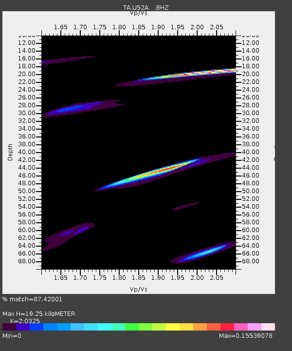
| Estimated Moho Depth: |
19.25 km |
| Estimated Crust Vp/Vs: |
2.03 |
| Assumed Crust Vp: |
6.476 km/s |
| Estimated Crust Vs: |
3.186 km/s |
| Estimated Crust Poisson's Ratio: |
0.34 |
|
| Radial Match: |
87.42001 % |
| Radial Bump: |
398 |
| Transverse Match: |
23.41721 % |
| Transverse Bump: |
254 |
| SOD ConfigId: |
478790 |
| Insert Time: |
2013-03-01 09:45:40.774 +0000 |
| GWidth: |
2.5 |
| Max Bumps: |
400 |
| Tol: |
0.001 |
|
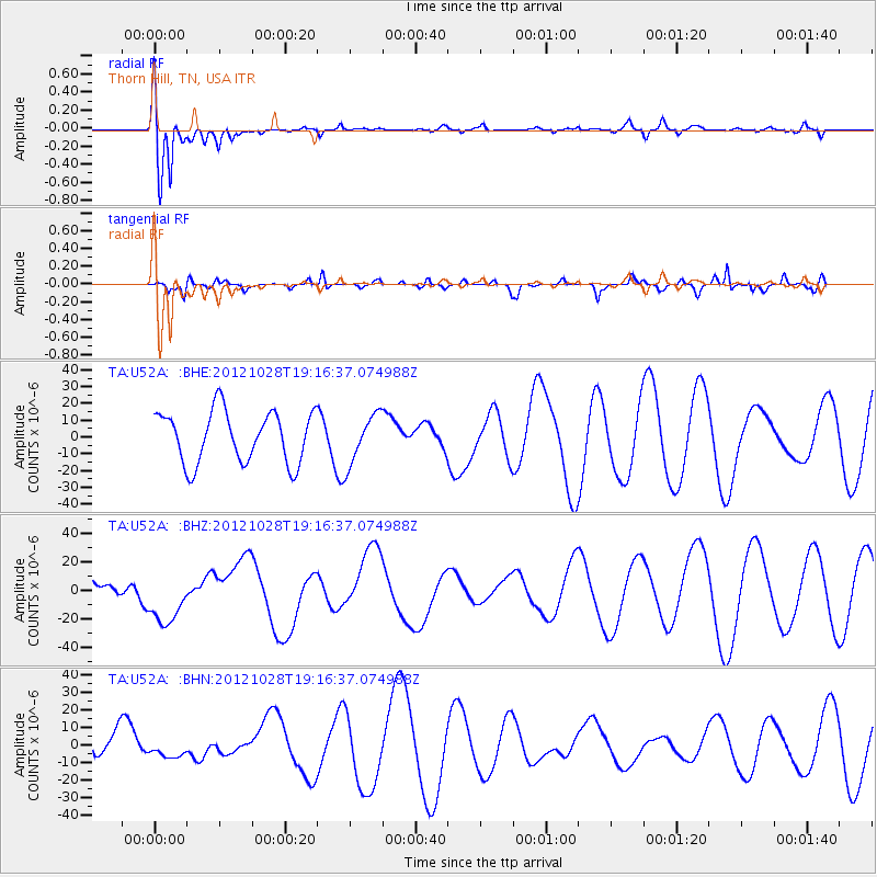
Signal To Noise
| Channel | StoN | STA | LTA |
| TA:U52A: :BHZ:20121028T19:16:37.074988Z | 2.1960561 | 1.840681E-5 | 8.381758E-6 |
| TA:U52A: :BHN:20121028T19:16:37.074988Z | 0.41025233 | 5.847602E-6 | 1.4253671E-5 |
| TA:U52A: :BHE:20121028T19:16:37.074988Z | 0.95895666 | 1.4739723E-5 | 1.5370582E-5 |
| Arrivals |
| Ps | 3.3 SECOND |
| PpPs | 8.4 SECOND |
| PsPs/PpSs | 12 SECOND |


