You are here: Home > Network List > TA - USArray Transportable Network (new EarthScope stations) Stations List
> Station S49A Springfield, KY, USA > Earthquake Result Viewer
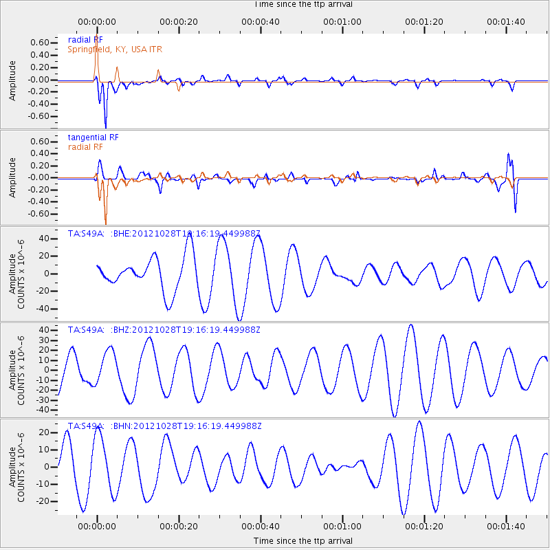
S49A Springfield, KY, USA - Earthquake Result Viewer
*The percent match for this event was below the threshold and hence no stack was calculated.
| Earthquake location: |
Queen Charlotte Islands Region |
| Earthquake latitude/longitude: |
52.3/-132.1 |
| Earthquake time(UTC): |
2012/10/28 (302) 19:09:53 GMT |
| Earthquake Depth: |
10 km |
| Earthquake Magnitude: |
5.6 MB, 5.8 MW, 5.5 MW |
| Earthquake Catalog/Contributor: |
WHDF/NEIC |
|
| Network: |
TA USArray Transportable Network (new EarthScope stations) |
| Station: |
S49A Springfield, KY, USA |
| Lat/Lon: |
37.78 N/85.29 W |
| Elevation: |
230 m |
|
| Distance: |
35.4 deg |
| Az: |
95.276 deg |
| Baz: |
309.475 deg |
| Ray Param: |
$rayparam |
*The percent match for this event was below the threshold and hence was not used in the summary stack. |
|
| Radial Match: |
90.95551 % |
| Radial Bump: |
400 |
| Transverse Match: |
28.69126 % |
| Transverse Bump: |
400 |
| SOD ConfigId: |
478790 |
| Insert Time: |
2013-03-01 09:45:56.853 +0000 |
| GWidth: |
2.5 |
| Max Bumps: |
400 |
| Tol: |
0.001 |
|
Signal To Noise
| Channel | StoN | STA | LTA |
| TA:S49A: :BHZ:20121028T19:16:19.449988Z | 1.0680443 | 1.66811E-5 | 1.561836E-5 |
| TA:S49A: :BHN:20121028T19:16:19.449988Z | 0.9241856 | 1.6252057E-5 | 1.7585275E-5 |
| TA:S49A: :BHE:20121028T19:16:19.449988Z | 1.8630548 | 3.5303514E-5 | 1.8949264E-5 |
| Arrivals |
| Ps | |
| PpPs | |
| PsPs/PpSs | |


