You are here: Home > Network List > TA - USArray Transportable Network (new EarthScope stations) Stations List
> Station N50A Nevada, OH, USA > Earthquake Result Viewer
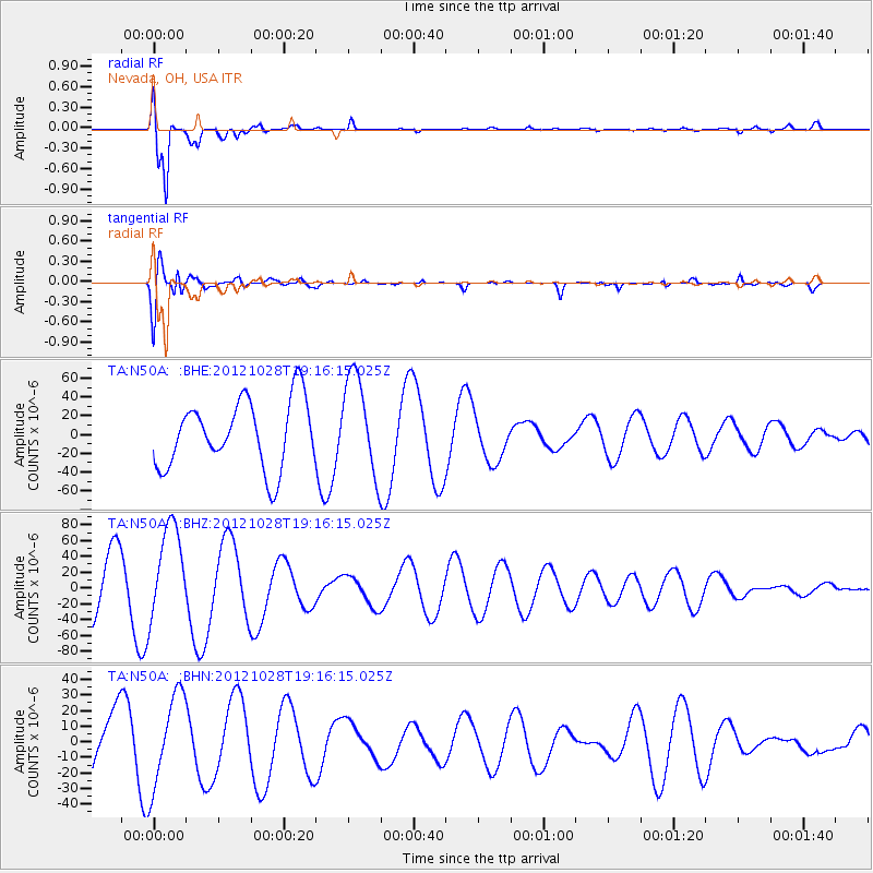
N50A Nevada, OH, USA - Earthquake Result Viewer
*The percent match for this event was below the threshold and hence no stack was calculated.
| Earthquake location: |
Queen Charlotte Islands Region |
| Earthquake latitude/longitude: |
52.3/-132.1 |
| Earthquake time(UTC): |
2012/10/28 (302) 19:09:53 GMT |
| Earthquake Depth: |
10 km |
| Earthquake Magnitude: |
5.6 MB, 5.8 MW, 5.5 MW |
| Earthquake Catalog/Contributor: |
WHDF/NEIC |
|
| Network: |
TA USArray Transportable Network (new EarthScope stations) |
| Station: |
N50A Nevada, OH, USA |
| Lat/Lon: |
40.77 N/83.15 W |
| Elevation: |
277 m |
|
| Distance: |
34.9 deg |
| Az: |
89.42 deg |
| Baz: |
306.037 deg |
| Ray Param: |
$rayparam |
*The percent match for this event was below the threshold and hence was not used in the summary stack. |
|
| Radial Match: |
95.700615 % |
| Radial Bump: |
400 |
| Transverse Match: |
55.449833 % |
| Transverse Bump: |
400 |
| SOD ConfigId: |
478790 |
| Insert Time: |
2013-03-01 09:46:09.753 +0000 |
| GWidth: |
2.5 |
| Max Bumps: |
400 |
| Tol: |
0.001 |
|
Signal To Noise
| Channel | StoN | STA | LTA |
| TA:N50A: :BHZ:20121028T19:16:15.025Z | 1.9413854 | 6.0205777E-5 | 3.101176E-5 |
| TA:N50A: :BHN:20121028T19:16:15.025Z | 1.0586749 | 2.9853305E-5 | 2.8198745E-5 |
| TA:N50A: :BHE:20121028T19:16:15.025Z | 1.4778868 | 5.2792955E-5 | 3.572192E-5 |
| Arrivals |
| Ps | |
| PpPs | |
| PsPs/PpSs | |


