You are here: Home > Network List > G - GEOSCOPE Stations List
> Station WUS Wushi, Xinjiang Uygur, China > Earthquake Result Viewer
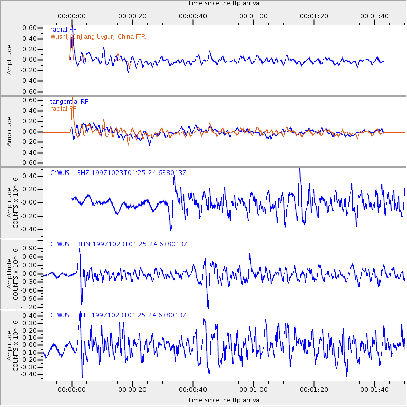
WUS Wushi, Xinjiang Uygur, China - Earthquake Result Viewer
*The percent match for this event was below the threshold and hence no stack was calculated.
| Earthquake location: |
Sumbawa Region, Indonesia |
| Earthquake latitude/longitude: |
-8.7/117.0 |
| Earthquake time(UTC): |
1997/10/23 (296) 01:16:01 GMT |
| Earthquake Depth: |
160 km |
| Earthquake Magnitude: |
5.5 MB |
| Earthquake Catalog/Contributor: |
WHDF/NEIC |
|
| Network: |
G GEOSCOPE |
| Station: |
WUS Wushi, Xinjiang Uygur, China |
| Lat/Lon: |
41.20 N/79.22 E |
| Elevation: |
1457 m |
|
| Distance: |
60.6 deg |
| Az: |
327.926 deg |
| Baz: |
135.912 deg |
| Ray Param: |
$rayparam |
*The percent match for this event was below the threshold and hence was not used in the summary stack. |
|
| Radial Match: |
76.29359 % |
| Radial Bump: |
400 |
| Transverse Match: |
56.5184 % |
| Transverse Bump: |
400 |
| SOD ConfigId: |
4480 |
| Insert Time: |
2010-02-27 01:09:44.113 +0000 |
| GWidth: |
2.5 |
| Max Bumps: |
400 |
| Tol: |
0.001 |
|
Signal To Noise
| Channel | StoN | STA | LTA |
| G:WUS: :BHN:19971023T01:25:24.638013Z | 7.063611 | 4.2682663E-7 | 6.0426125E-8 |
| G:WUS: :BHE:19971023T01:25:24.638013Z | 2.1500769 | 1.8907812E-7 | 8.7940165E-8 |
| G:WUS: :BHZ:19971023T01:25:24.638013Z | 3.3844914 | 1.9123483E-7 | 5.6503268E-8 |
| Arrivals |
| Ps | |
| PpPs | |
| PsPs/PpSs | |


