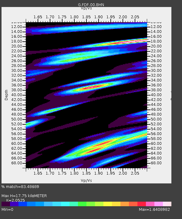
FDF Fort de France, Martinique France - Earthquake Result Viewer

Earthquake location: Queen Charlotte Islands Region
Earthquake latitude/longitude: 52.4/-131.9
Earthquake time(UTC): 2012/10/30 (304) 02:49:02 GMT
Earthquake Depth: 9.0 km
Earthquake Magnitude: 5.8 MB, 6.0 MS, 6.2 MW, 6.2 MW
Earthquake Catalog/Contributor: WHDF/NEIC
Network: G GEOSCOPE
Station: FDF Fort de France, Martinique France
Lat/Lon: 14.73 N/61.14 W
Elevation: 467 m
Distance: 66.7 deg
Az: 96.053 deg
Baz: 320.932 deg
Ray Param: 0.057429083
Estimated Moho Depth: 17.75 km
Estimated Crust Vp/Vs: 2.05
Assumed Crust Vp: 5.88 km/s
Estimated Crust Vs: 2.865 km/s
Estimated Crust Poisson's Ratio: 0.34
Radial Match: 83.48689 %
Radial Bump: 400
Transverse Match: 72.559006 %
Transverse Bump: 400
SOD ConfigId: 478790
Insert Time: 2013-03-01 10:01:52.981 +0000
GWidth: 2.5
Max Bumps: 400
Tol: 0.001

Signal To Noise

ChannelStoNSTALTA
G:FDF:00:BHZ:20121030T02:59:22.400005Z4.2157621.1928813E-62.8295744E-7
G:FDF:00:BHN:20121030T02:59:22.400005Z2.21731336.4369345E-72.9030335E-7
G:FDF:00:BHE:20121030T02:59:22.400005Z2.30770185.572658E-72.4148088E-7
Arrivals
Ps3.3 SECOND
PpPs9.0 SECOND
PsPs/PpSs12 SECOND